Archive for September, 2014

Ben's Chili Bowl

Ben’s Chili Bowl

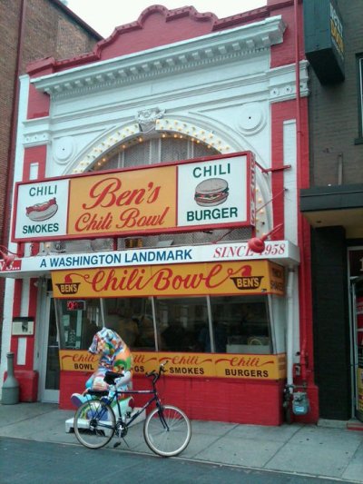
September’s end-of-the-month restaurant review is of Ben’s Chili Bowl. A D.C. landmark restaurant, it is located in northwest D.C.’s Shaw neighborhood, next to The Lincoln Theatre, in an historic building at 1213 U Street (MAP).  Built in 1910, the building originally housed the city’s first silent movie house, named The Minnehaha Theater. Later, Harry Beckley, one of D.C.’s first Black police detectives, converted it into a pool hall.  A family-run business, Ben’s Chili Bowl was originally opened by Ben Ali, a Trinidadian-born immigrant who had studied dentistry at nearby Howard University, and his fiancee, Virginian-born Virginia Rollins. They were married seven weeks after opening the restaurant.  Today it is run by their sons, Kamal and Nizam.

From the unrest of the late 1960’s race riots that followed the assassination of Martin Luther King, Jr., to the tough economic times in the 1970’s and 1980’s that resulted from the destruction of much of the neighborhood’s businesses during the riots, and finally to the revitalization and gentrification of the U Street Corridor beginning in the 1990’s, Ben’s has survived and seen it all. Over 50 years later, Ben’s remains as it has always been, right down to the red booths and bar stools and Formica counters, which are the original ones from when the restaurant first opened. Even Ben’s large neon “Home of the Famous Chili Dog” hearkens back to an earlier time.

Locals and tourists, as well as celebrities including Bill Cosby, Chris Tucker and Bono, and politicians such as President Barack Obama and French President Nicolas Sarkozy, have flocked to Ben’s Chili Bowl for decades for its rich history, friendly atmosphere and delicious food.  A sign at the restaurant, however, notifies patrons that only Mr. Cosby and the Obama family eat for free.

The menu at Ben’s includes the traditional hot dogs and hamburgers and fries, as well as more recently added healthier choices such as turkey dogs and vegetarian burgers. But I must confess that I have not tried any of these offerings. It seems almost wrong to go to Ben’s and not have what they are most famous for.

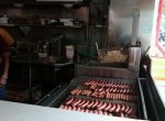
Ben’s namesake chili is still made according to the original recipe, and comes complete with chunks of ground beef, green peppers and onions, and is filled with spices to tantalize your taste buds. The chili is available by the bowl, as well as how I prefer it – as a condiment for the hot dogs, French fries, and just about anything else on the menu. But my recommendation is to try “Bill Cosby’s Original Chili Half-smoke.” Originally made famous by Ben’s in 1958 and a favorite of Mr. Cosby’s since the early 1960s, it is a mouth-watering and juicy half-pork and half-beef smoked sausage, topped with their spicy chili, on a warm steamed bun. It is considered not only Ben’s, but D.C.’s signature dish.

Recently, Ben’s Chili Bowl has also expanded by opening a new restaurant and bar called Ben’s Next Door, in addition to outposts at Nationals Park and FedEx Field, Ronald Reagan Washington National Airport, and across the river in Rosslyn neighborhood of Arlington, Virginia. And although the food is the same, there is something about the original location that makes everything just a little bit better.  But don’t take my word for it.  You don’t even have to believe the prestigious James Beard Foundation, which named Ben’s one of the “down-home eateries that have carved out a special place on the American culinary landscape.”  I recommend that you stop by and try it for yourself.

BensChiliBowl03     BensChiliBowl02
[Click on the thumbnails above to view the full size photos]

Nationals Park

Nationals Park

The Washington Nationals played their last home game of the 2013 regular season yesterday, and beat the Florida Marlins by a score of 1 to 0 in an exciting end-of-the-year finale.  In picking up the win, Pitcher Jordan Zimmermann threw the first no-hitter in franchise history, and the first no-hitter by a Washington major league pitcher since Bobby Burke of the Washington Senators no-hit the Boston Red Sox on August 8, 1931, at Griffith Stadium.

The Nationals go into the post-season as the League’s top seed after having clinched their second National League East title in three years when they beat the rival Braves, the team that knocked them out of the top spot last season, in Atlanta back on September 16th.  With yesterday’s win they finish the regular season with a record of 96 wins and 66 losses, the best in the National League, and quite a change from their first season at Nationals Park just six years ago, when they finished with a league-worst record of 59 wins and 102 losses.

In recognition and celebration of their successful season, on this bike ride I rode to Nationals Park. The ballpark is located at 1500 South Capitol Street (MAP), within site of the U.S. Capitol Building, in the fast-developing Capitol Riverfront district along the Anacostia River, near The Washington Navy Yard in the Navy Yard neighborhood of southeast D.C.

Nationals Park was designed by Populous and Devrouax & Purnell Architects and Planners.  It was originally estimated to cost $611 million, but eventually cost $693 million to build, with an additional $84.2 million spent on transportation, art, and infrastructure upgrades to support the stadium for a total cost of $783.9 million. The exterior facade of the park features an innovative design of steel, glass and pre-cast concrete to create a facility that uniquely reflects the architecture of the National Capital City. Inspiration for the look of the ballpark was taken from the East Wing of the National Gallery of Art, a structure designed by famed architect I.M. Pei.

The ballpark was originally designed to seat 41,888 fans, but for a variety for reasons the park’s capacity has been reduced over the last few years to 41,546 in 2010, then 41,487 in 2012, and finally down to 41,418 and 79 luxury suites on three levels around the infield in 2013.

It should be noted that Nationals Park is bicycle friendly, with a free bike valet for every Nationals game in Parking Garage C, which is located at the corner of 1st and N Streets. Additionally, there are over 250 bike racks in and around the Park. Each year the team also has an “Annual Bike to the Park Day” in conjunction with the Washington Area Bicycle Association and “National Bike to Work Day.”

Ground breaking for the park took place in early 2006, and thanks to an ambitious construction schedule it was completed just two years later. The George Washington University Colonials christened the park, playing the first game there on March 22, 2008. The local collegiate team beat Philadelphia’s Saint Joseph’s University Wildcats in a 9 to 4 victory. One week later the Nationals played their first game in the new ballpark, defeating the Baltimore Orioles, 3–0, in an exhibition game on March 29, 2008. The following day, the Nationals opened the 2008 MLB season in Nationals Park with a rare one-game series against the Atlanta Braves, which served as the first official MLB game at the park. True to tradition, President George W. Bush threw out the ceremonial first pitch. In an omen of things to come, the Nationals won the game by a score of 3 to 2 with a walk-off home run from Ryan Zimmerman.

NationalsPark02     NationalsPark06

NationalsPark03     DandyHorse03
[Click on the photos to view the full-size versions]

Crystal City Water Park

Crystal City Water Park

On this bike ride I left D.C. via the 14th Street Bridge, and went for a ride on the trails in Virginia. I starting out on the Mount Vernon Trail, and then rode south past Gravelly Point Park and Ronald Reagan Washington National Airport. But instead of continuing south, I decided to turn off and take one of the side trails. So I turned west and went through a tunnel, and discovered a park I did not know about before. It is called the Crystal City Water Park, and is located at 1750 Crystal Drive (MAP), between 15th and 18th Streets in the Crystal City neighborhood of Arlington County.

Depending on the time of day, Crystal City Water Park can be a quiet, serene setting, with the sound of the water from the multiple fountains and waterfalls adding to the calm. During these times it provides an ideal setting for those seeking a place to de-stress. At other times, such as mid-day during the week, the park often fills up with nearby office workers having lunch. There is a small restaurant located in the park named The Water Park Café, which serves Mediterranean, Egyptian and American food. And whether you get your lunch from the Café or brown-bag it from home, there is plenty of outdoor seating.

The park is the site of many scheduled, organized activities as well. For example, Mind Your Body Oasis offers free yoga in the park at 7:00 am on Monday mornings during the warmer weather between May and September. And a local wine shop named Vintage Crystal sponsors events called “Wine in the Water Park,” which features interesting wine varietals and great live music on Fridays evenings in June and September.

Similar in a way to the plane watching in nearby Gravelly Point Park, another favorite activity in Crystal City Water Park is train watching. By walking up the path to the “observation deck” area on top of the park’s wall of water, you can see the trains go by on the three tracks that pass by the back of the park.  But unlike the planes at Gravelly Point, if you wave to the passing trains you may just get a wave back from the conductor and maybe a toot from the train whistle too if you’re lucky.

CrystalCityWaterPark05     CrystalCityWaterPark03     CrystalCityWaterPark06

CrystalCityWaterPark07     CrystalCityWaterPark02     CrystalCityWaterPark09
[Click on the thumbnails above to view the full size photos]
Boundary Castle

Boundary Castle

While on a bike ride along 16th Street near Florida Avenue (MAP) in northwest D.C., I found an old, sturdy brownstone retaining wall and what appears to be an ornate entry gate leading to nowhere.   I later found out that they were once part of a property known as Boundary Castle. Also sometimes referred to as Henderson Castle or Prospect Castle, Boundary Castle was a mansion located on the border of D.C.’s Adams Morgan and Columbia Heights neighborhoods, and was the family home of John Brooks Henderson and Mary Foote Henderson.

John was a former U.S. Senator from Missouri. He was initially appointed to the Senate in 1862 to replace Trusten Polk, who had been expelled from Senate for his support of the South in the Civil War. He was later elected and served one full term. He was best known for authoring the 13th Amendment abolishing slavery. He was also remembered for breaking party ranks, and along with six other Republican senators voting for acquittal in the impeachment trial of President Andrew Johnson. After leaving the Senate, he and his wife Mary moved back to St. Louis.

While back in Missouri, Mary founded the St. Louis School of Design and authored “Practical Cooking and Dinner Giving” and “Diet for the Sick, A Treatise on the Values of Foods.” Meanwhile, John was busy buying up enormous quantities of supposedly worthless bonds that Missouri counties had issued after the Civil War. Purchased at ten cents on the dollar, the bonds became valuable when the courts ordered counties to pay their full face value. In 1889, after accumulating a massive fortune, the Hendersons moved back to D.C.

Upon arriving back in D.C., the Hendersons needed a fitting place to live, so they had a massive, Romanesque Revival-style mansion built. The house was designed by Massachusetts architect Eugene C. Gardner, and was supposedly modeled after a castle Mary had seen in Europe. The sprawling was made from Seneca sandstone, the same material used in the Smithsonian, and boasted 30 rooms. They named it Boundary Castle.

The Hendersons also bought up approximately 300 lots outside the northern boundary of the city in the area, then known as Meridian Hill, in the hope they could develop the area into the center of Washington society during the height of the Gilded Age. Their interest in the immediate neighborhood also coincided with the City Beautiful Movement of the early 20th century. This reform philosophy of North American architecture and urban planning flourished during the 1890s and 1900s with the intent of introducing beautification and monumental grandeur in cities. However, it promoted beauty not only for its own sake, but also to instill moral and civic virtue among urban populations.

With a genuine interest in civic improvement, Mary frequently lobbied Congress for various projects to improve and beautify the Meridian Hill area. In 1900, she supported a plan by architect Franklin W. Smith to construct a colossal presidential mansion on Meridian Hill to replace The White House. However, this plan never came to fruition. She was, however, successful in lobbying Congress to support the acquisition of the land and its eventual development as Meridian Hill Park. She also had lavish palaces and mansions built on the properties they owned to be rented or sold to government officials and diplomats.

Real estate development was not Mary’s only interest during this time, however. She also became an impassioned advocate for healthy living, and wrote another book entitled ” The Aristocracy of Health: A Study of Physical Culture, Our Favorite Poisons, and a National and International League for the Advancement of Physical Culture.” She was known to throw lavish dinner parties, which were always strictly vegetarian, and alcohol-free. It was also during this time that Mary famously decided to dispose of the plentiful and expensive wine collection John had accumulated over the years. She had her butler and others bring the wine bottles up from the castle’s cellars and smash them on a large rock in the front lawn. Newspaper accounts of the incident reported that there was so much wine that it ran down into the gutters of 16th Street.

John passed away in 1913 at the age of 86. Mary remained in Boundary Castle for the next 18 years, before passing away in 1931 at the age of 88. After her death, Bondary Castle was rented by a man named Bert L. Williams, who reopened it as the Castle H Tennis and Swimming Club. In what would have been abhorrent to Mary, he also turned the castle’s ballroom into a stand-up bar. As early as 1935, there had been talk of tearing down the old castle, but it hung on until January 1949, when it was finally razed. Wealthy neighbors Eugene and Agnes Meyer had purchased the mansion in order to get rid of the rowdy club. Today, the site is home to 216 townhouses known collectively as Beekman Place.

BoundaryCastle01     BoundaryCastle03     BoundaryCastle04

The Korean War Veterans Memorial

The Korean War Veterans Memorial

On this ride Julius and I went to one of D.C.’s “major” memorials, the Korean War Veterans Memorial. Located in southwest D.C.’s West Potomac Park, just south of The Reflecting Pool on the National Mall (MAP), the memorial commemorates the sacrifices of the 5.8 million Americans who served in the U.S. armed services during the three-year period of the Korean War.

On June 25, 1950, North Korean military forces surprised the South Korean army, and the small U.S. force stationed in the country, and quickly headed toward the capital city of Seoul. The U.S. responded by pushing a resolution through the United Nations Security Council calling for military assistance to South Korea. The Soviet Union was not present to veto the action as it was boycotting the Security Council at the time. With this resolution in hand, President Harry Truman rapidly dispatched U.S. land, air, and sea forces to Korea to engage in what he termed a “police action.” The U.S. intervention turned the tide, and U.S. and South Korean forces marched into North Korea. This action, however, prompted the massive intervention of communist Chinese forces in late 1950. The war in Korea subsequently bogged down into a bloody stalemate. On July 27, 1953, the U.S. and North Korea signed a cease-fire that ended the conflict. The cease-fire agreement also resulted in the continued division of North and South Korea at just about the same geographical point as before the conflict.

The Korean War was the first “hot” war of the Cold War. Korea was the first “limited war,” one in which the U.S. aim was not the complete and total defeat of the enemy, but rather the “limited” goal of protecting South Korea. For the U.S. government, such an approach was the only rational option in order to avoid a third world war and to keep from stretching finite American resources too thinly around the globe. It proved to be a frustrating experience for the American people, who were used to the kind of total victory that had been achieved in World War II. The public found the concept of limited war difficult to understand or support and the Korean War never really gained popular support.

The war was one of the most hard-fought in American history. During its relatively short duration, 54,246 Americans died in support of their country. Of these, 8,200 are listed as missing in action or lost or buried at sea. An additional 103,284 Americans were wounded during the conflict.  An estimated 2.5 million civilians were also killed or wounded.

The main portion of the memorial honoring these men and women is in the form of a triangle intersecting a circle. Within the walled triangle are 19 stainless steel statues, which represent an ethnic cross section of America. Each statue is larger than life-size, measuring between 7 feet 3 inches and 7 feet 6 inches tall, and weighing nearly half a ton. The figures represent a squad on patrol, drawn from each branch of the armed forces; fourteen of the figures are from the U.S. Army, three are from the Marine Corps, one is a Navy Corpsman, and one is an Air Force Forward Air Observer. They are dressed in full combat gear, dispersed among strips of granite and juniper bushes which represent the rugged terrain of Korea.

The main reflection wall along the south side of the triangle is 164 feet long, 8 inches thick; and made from more than 100 tons of highly polished “Academy Black” granite. More than 2,500 photographic, archival images depicting soldiers, equipment and people involved in the war are sandblasted onto the wall. When the statues are reflected on the wall, there appear to be 38 soldiers, representing the 38th parallel. To the north of the statues is a path, forming another side of the triangle. Alongside the path, forming the second side of the triangle is the United Nations Wall, a low wall listing the 22 members of the United Nations that contributed troops or medical support to the Korean War effort.  The third side of the triangle, facing towards The Lincoln Memorial, is open.

The memorial’s circle contains the Pool of Remembrance, a shallow pool 30 feet in diameter lined with black granite and surrounded by a grove of linden trees with benches. The trees are shaped to create a barrel effect, which allows the sun to reflect on the pool. Inscriptions list the numbers killed, wounded, missing in action, and held as prisoners of war, and a nearby plaque is inscribed: “Our nation honors her sons and daughters who answered the call to defend a country they never knew and a people they never met.” Additionally, next to the information about the American soldiers is information about the United Nations troops.

The meaning of the memorial is perhaps most captured by a message embedded in one of its granite walls, which bears the simple message, inlaid in silver: “Freedom Is Not Free.”

KoreanWarVeteransMemorial02     KoreanWarVeteransMemorial03     KoreanWarVeteransMemorial04

KoreanWarVeteransMemorial07     KoreanWarVeteransMemorial05     KoreanWarVeteransMemorial06

KoreanWarVeteransMemorial12     KoreanWarVeteransMemorial09     KoreanWarVeteransMemorial11


The Metropolitan Branch Trail

The Metropolitan Branch Trail

On this ride I explored the Metropolitan Branch Trail, which is an eight-mile trail that runs through the middle of D.C. (MAP), from Union Station downtown all the way to the Baltimore and Ohio (B&O) Railroad Station in Silver Spring, Maryland. Seven miles of the trail are within the city limits, and one mile is in Maryland. The trail gets its name from the Metropolitan Branch Line of the B&O Railroad, which the trail parallels. It is technically considered a rail-trail conversion because a key section of the trail is on former B&O Railroad right-of-way.

The urban trail takes cyclists past graffiti, industrial sites, train tracks, a brewery, and a touch of greenery as it passes through several of D.C.’s vibrant and historic neighborhoods, including the NOMA, Edgewood, Eckington and Brookland neighborhoods. Used much more for utilitarian purposes than for recreation, the trail is an important transportation route providing connections to homes and work, as well as access to seven Metro stations, and the National Mall.

However, the Metropolitan Branch Trail currently remains unfinished.  Plans for the future include connections to the area’s trail network such as the Capital Crescent Trail, Anacostia Trails System, and integration into the East Coast Greenway.

MBT01     mbt22     MBT07

mbt21     mbt20     MBT09     MBT01
[Click on the thumbnails above to view the full size photos]

Memorial to Orlando Letelier

Memorial to Orlando Letelier

It was 38 years ago today that Orlando Letelier, a former Chilean government minister, diplomat and ambassador to the U.S., was assassinated here in D.C. I was only 14 years old at the time, but I remember it happening because of the unusual and audacious method by which he was killed – a car bomb.

Marcos Orlando Letelier del Solar was a Chilean economist, Socialist politician and diplomat during the presidency of Socialist President Salvador Allende. After a military coup d’état led by General Augusto Pinochet overthrew the government in 1973, Letelier was arrested. He spent approximately a year in prisons and various concentration camps, including the infamous Dawson Island, which was used by the Allende regime to house political prisoners suspected of being communist activists. After diplomatic pressure from Venezuelan government prompted his release, Letelier moved to D.C. at the invitation of writer and film-maker Saul Landau to work at the Institute of Policy Studies, a left-wing think tank. He then became the leading voice of Chilean resistance to Pinochet, lobbying Congress and European powers to stop trading with the military dictatorship of American-backed General Pinochet.

Approximately a year after coming to D.C., on September 21, 1976, Letelier was on his way to work like any other day, except that he was giving his assistant, Ronni Karpen Moffitt, and her husband, Michael, a ride because their car had broken down. Letelier was driving, while Ronni was in the front passenger seat and Michael was in the rear behind his wife. As they rounded Sheridan Circle in northwest D.C. at approximately 9:35 am, a violent explosion under the car lifted it off the ground and caused it to collide with another car that happened to be parked illegally in front of the Irish embassy.

Michael was able to escape from the car by crawling out where the shattered rear window. Assuming Ronni was alright when he saw her get out of the car and stumble away, he made his way around the car to check on Letelier, who was still in the driver’s seat. Letelier’s lower torso was blown away and his legs were severed, but he was still alive. Both Ronni and Letelier were taken to the George Washington University Medical Center. Letelier succumbed to the massive injuries suffered in the explosion approximately 20 minutes later.   Ronni’s died a little over an hour later, her larynx and carotid artery having been severed by a piece of shrapnel from the bomb. Michael suffered only a minor head wound.

An FBI investigation determined that the assassination had been orchestrated by agents of the Dirección de Inteligencia Nacional (DINA), the Chilean secret police, led by an American named Michael Townley, who was a DINA U.S. expatriate who had once worked for the CIA, along with right-wing Cuban militants who they had hired to carry out the hit. Townley was extradited to the U.S., and agreed in a plea deal to provide evidence against his co-conspirators in exchange for pleading guilty to a single charge of conspiracy to commit murder and being given a ten-year sentence. Townley’s wife, Mariana Callejas, also agreed to testify in exchange for not being prosecuted. The Chilean government refused to extradite two DINA officials who were involved, but they were tried and convicted in Chile, and sentenced to between 6 and 7 years in prison. The Cubans were tried in the U.S. and sentenced to life in prison. Soon after the trial, Townley was freed under the Witness Protection Program.   General Pinochet, who died in December of 2006, was never charged or brought to trial for the murders, despite CIA evidence implicating him as having ordered the assassination.

On this bike ride, I rode to the Letelier-Moffitt Memorial at the site of the bombing in which they were killed. The memorial is located in the southwest area of Sheridan Circle, near 23rd Street and Massachusetts Avenue (MAP) in northwest D.C.’s Embassy Row neighborhood. The memorial consists of a small brass plaque embedded in the grass between the sidewalk and the curb where they were killed, near the Irish and Romanian embassies.

Letelier01a

Prince William Forest Park

Prince William Forest Park

This year, the autumnal equinox brings the fall season to the Northern Hemisphere tomorrow night at 10:29 P.M. Eastern Daylight Time. This is my favorite time of the year. So to celebrate the beginning of autumn, on this bike ride I went for a long weekend ride in the Prince William Forest Park, which is located between a half an hour and forty-five minutes south of D.C., just off of Interstate 95 (MAP) in southeastern Prince William County, Virginia, and adjacent to the Marine Corps Base Quantico.  I went early in the morning, and enjoyed a breakfast of a pumpkin muffin and some apple juice, and then went for a leisurely ride in the picturesque park to enjoy the early fall foliage as the landscape is beginning to silently explode with vibrant colors of red, yellow, and orange.

Prince William Forest Park is the largest protected natural area in the D.C. metro area at over 19,000 acres. It was originally developed by Works Progress Administration workers after the Great Depression, and established as the Chopawamsic Recreational Demonstration Area in 1936. It later became a National Park and was renamed Prince William Forest Park in 1948.  The park is currently administered by the National Park Service, whose architects designed its landscaping and structures to be a glimpse into the past and provide an example of what much of the East Coast once looked like centuries ago.

The park offers 21 miles of bicycle accessible roads and trails, as well as a variety of other recreational opportunities. They include an additional 37 miles of hiking trails, some of which go to historical and cultural destinations within the park, including the remnants of an old pyrite mine and an abandoned gold mine, as well as Joplin, Hickory Ridge and Batestown – three small communities that existed prior to the park’s establishment. Other trails follow Quantico Creek and offer views of its small waterfalls. Prince William Forest Park also offers several tent camping options, including family, group and backcountry camping, as well as rustic cabin camping, and a full-service, concessionaire-operated RV campground. Four of the parks camp areas are listed individually on the National Register of Historic Places. Wildlife viewing is also a popular activity in the park.

     PrinceWilliamForestPark02     PrinceWilliamForestPark06

PrinceWilliamForestPark03     PrinceWilliamForestPark05     PrinceWilliamForestPark04

Arlington Memorial Bridge

Arlington Memorial Bridge

Widely regarded as D.C.’s most beautiful bridge, Arlington Memorial Bridge spans the Potomac River and is one of nine bridges that connect the National Capital City to the Commonwealth of Virginia. It is located at the western end of the National Mall (MAP), and in part constitutes a formal terminus of the Mall.

A masonry, steel, and stone arch bridge with a central drawbridge, Arlington Memorial Bridge was designed in the Neoclassical architectural style. Except for the draw span, the bridge is of reinforced concrete construction faced with dressed North Carolina granite ashlar. The draw span is of the double leaf, underneath counterweight type and is faced with pressed ornamental steel made to blend with the masonry spans. At the time it was built, the draw span was the longest, heaviest and fastest in the world, although it is now sealed and inoperative. The bridge is 2,163 feet long, carrying a 60-foot-wide roadway and 15-foot sidewalks on either side.

Arlington Memorial Bridge also contains some ornamental characteristics typical of the “City Beautiful Movement” which was taking place in D.C. at the time it was designed. This reform philosophy of North American architecture and urban planning flourished during the 1890s and 1900s with the intent of introducing beautification and monumental grandeur in cities. However, it promoted beauty not only for its own sake, but also to instill moral and civic virtue among urban populations. The northeastern entrance to the Arlington Memorial Bridge features “The Arts of War” sculptures, Sacrifice and Valor, which were completed by Leo Friedlander in 1951. On the pylons of each pier of the bridge are large circular discs with eagles and fasces designed by sculptor Carl Paul Jennewein.

Congress first proposed a bridge at the site of the current structure on May 24, 1886. However, the bridge went unbuilt for decades thanks to political quarrels over whether the bridge should be a memorial, and to whom or what. Then in November of 1921, President Warren G. Harding was travelling to the dedication ceremony for the Tomb of the Unknown Soldier at Arlington National Cemetery when he was caught in a three-hour traffic jam because the existing bridges at the time could not handle the traffic. Resolving to prevent that from happening again, President Harding sought an appropriation to fund the work to build a bridge. Congress subsequently approved his request in June of the following year. Construction finally began in 1927, and took six more years to complete. The dedication ceremony was on January 16, 1932, headed by President Herbert Hoover. Arlington Memorial Bridge was added to the National Register of Historic Places in 1980.

Today Arlington Memorial Bridge is a major entryway and commuter route into the city. But the years of heavy use have taken their toll, and although the bridge has received various relatively minor repairs over the years, it has never had a major overhaul or restoration. In a report two years ago, the Federal Highway Administration called for a complete overhaul of the bridge. And after a major inspection of the bridge, the National Park Service transportation division head Charles N. Borders, II, stated “The bridge … is really at the end of, and beyond, its life cycle.”

ArlingtonMemorialBridge03     ArlingtonMemorialBridge01a     MemorialBridge3

BookHilPark1

Book Hill Park

While I was riding around northwest D.C.’s Georgetown neighborhood on a recent bike ride I happened upon Book Hill Park, which is located at the corner of Reservoir Road and Wisconsin Avenue (MAP). From the southern entrance it appeared to be just another D.C. park, but I discovered that there’s to it than meets the eye. The Georgetown branch of the D.C. Public Library is located at the top of the hill at the northern end of Book Hill Park.

The location of the park was formerly the site of the original Georgetown Reservoir from 1859 to 1932. This reservoir was part of the larger Washington Aqueduct, America’s first public water system. This system, created between 1853 and 1863, still collects water from the Potomac River far upriver at Great Falls, and feeds the city through the original aqueduct system. Just down Reservoir Road from Book Hill Park is the newer and larger Georgetown Reservoir, which holds water from this system today.

After being converted into a park, it eventually fell into a state of neglect and disrepair. Book Hill Park had become a mess of overgrown brush and was lacking amenities. But local community members organized to do something about it. Forming The Friends of Book Hill Park in 2000, they cleaned up the property. Then in 2005, the remaining sections of the original 1871 fence were restored, and the signs were placed. Numerous flowers and trees have since been planted on the hillside, including thousands of daffodils and even some several cherry trees donated by the Japanese Embassy.

There is a set of stone steps leading to the top of the hill, where visitors can enjoy sweeping views of Georgetown and across the Potomac to nearby Rosslyn. Offering a quiet repose from the busy streets of Georgetown, the park provides benches and shade for library patrons for reading or resting. Passers-by, people from the neighborhood, and everyone else are also welcome at the public park.

In recent years this small neighborhood park has become known locally for being home to an annual Fourth of July Doggie Parade. To promote the park, the Friends of Book Hill Park began this tradition in 2002. It is an “all-American” family-oriented event which has grown to include many area canines, who are judged for their good looks and talents in seven categories, as well as Best in Show. For the parade the canines and their owners descend down the park’s grand staircase and then parade down Wisconsin Avenue, All led by Uncle Sam. It’s not one of the city’s larger celebrations, but it is one of the most unusual ones.

BookHilPark2        BookHilPark3