Posts Tagged ‘Civil War’

FortTotten01

Fort Totten

Today I rode to Fort Totten Park in Northeast D.C., which is located on Fort Totten Drive (MAP), which is also the name of the neighborhood where the park is located.  It is a Civil War memorial on the site of a Union fort, and is one of the historic sites on the Fort Circle Park National Recreation Trail.  The park is under the management of the National Park Service.

Located Built in 1861 and named after Brigadier General Joseph Gilbert Totten, Chief of the Army Corp of Engineers, Fort Totten commanded the countryside of D.C. during the Civil War. Heavily armed with massive cannons that could hurl 100-pound projectiles several miles, Fort Totten halted the eastward advance of the Confederates inside D.C. during the Battle of Fort Stevens in July of 1864, and resulted in Lieutenant General Jubal Early’s retreat into Virginia, ending the last Confederate invasion of a Northern state during the Civil War.

By the late 1920’s the historic earthenworks inside Fort Totten showed significant signs of erosion which threatened the preservation of the fort. To stabilize the fort vegetation was planted. Today, removal of vegetation from the fort and its grounds is prohibited. The site is in a relatively good state of preservation today, and is maintained as an adjunct to Rock Creek Park.

FortTotten06     FortTotten08     FortTotten03

FortTotten04     FortTotten05
[Click on the photos to view the full-size versions]

StFrancisDeSales01

Saint Francis de Sales Church

On this bike ride I rode aimlessly for quite a while and surprised myself when I found out that I was in Maryland.  Eventually I turned around and headed back toward downtown D.C. And as I was riding along a modest old stone church on the side of the road caught my eye. Because it looked so interesting to me, I stopped to see it and find out more. It turned out to be Saint Frances de Sales Church, and it is located at 2021 Rhode Island Avenue (MAP) In northeast D.C.’s Langdon neighborhood.

The first thing I learned about Saint Francis de Sales Church is that it is a Catholic church with the oldest continuing congregation in D.C.  I learned this from a plaque on the front of the building.  The remainder of the plaque reads, “Congregation began about 1722, when Catholics first attended mass at chapel within Queen family mansion. About 1723 chapel was built outside mansion, on site approximately at present Evarts Street, N.E., near 20th Street. Building came to be called Queen’s Chapel. Destroyed by fire three times: In American Revolution (date uncertain): War of 1812 (1814); and Civil War (1862).  Rebuilt each time: Last time as St. Francis de Sales church (1908). Each new building attended by members of congregation that had attended at older building. St. Francis de Sales Church moved to present site in 1927. Last Queen’s Chapel building is now gone.”

The next thing I wanted to learn about was Francis de Sales and who he was, which I researched later when I got home.  Francis de Sales was a Bishop of Geneva and is honored as a saint in the Catholic Church. Born on August 21, 1567, to a noble family at Chateau de Sales in the Kingdom of Savoy near Geneva, Switzerland, he knew from a very early age that he desired to serve God and had a vocation to the priesthood. However, he kept it from his family. His father wanted him to enter a career in law and politics. And he pursued those studies while waiting for God to make His will clear.  Francis stated, “I had to know fully what God himself wanted. I had to be sure that everything in this should be done as though his hand had done it.” So Francis waited. Then one day, while he was riding. Francis fell from his horse three times that day. And every time he fell, his sword came out of the scabbard, and every time it came out, the sword and scabbard came to rest on the ground in the shape of the Christian cross. Taking this as a sign, he told his father. And after much discussion and disagreement from his father, Francis was ordained to the priesthood and elected provost of the Diocese of Geneva, in 1593, by the Bishop of Geneva.

Although he lived to be only 55 years old, through his 29-year career he became noted for his deep faith and his gentle approach to the religious divisions in his land resulting from the Protestant Reformation. He is known also for his writings on the topic of spiritual direction and spiritual formation, particularly the Introduction to the Devout Life and the Treatise on the Love of God.

St. Francis de Sales was beatified on January 8, 1661 and canonized on April 19, 1665 by Pope Alexander VII.  In 1923, Pope Pius XI named St. Francis de Sales the patron saint of Catholic writers and the Catholic press because of the tracts and books he wrote. He is also the patron saint of the deaf, journalists, adult education, and the Sisters of St. Joseph. His feast day is celebrated on January 24th.

Its long history combined with its present leadership and parishioners has combined to make today’s Saint Frances de Sales Church a vibrant presence in its neighborhood and the city.  The church has Mass with Cantor, Traditional Latin Mass and/or Gospel services six days a week, as well as scheduled confessions and Adoration Holy Hours, and active Christian education and fellowship communities.  So every indication is that it will continue well into the future as it did for so long in the past.

StFrancisDeSales02     StFrancisDeSales03     StFrancisDeSales04
[Click on the thumbnails above to view the full size photos]

AACWM01

The African American Civil War Memorial

During this bike ride I visited The African American Civil War Memorial, which is located at the corner of Vermont Avenue, 10th Street and U Street (MAP), near the eastern entrance to the U Street Metro station, in northwest D.C.’s Shaw neighborhood. I couldn’t help but think that it might be better located elsewhere, such as near the National Mall, so that it might get more visitors. But the memorial is appropriately located in Shaw inasmuch as the neighborhood was named after Robert Gould Shaw, the colonel in charge of the Massachusetts 54th Regiment during the Civil War. The 54th saw extensive service in the Union Army during the war, and was the second African American regiment, following the 1st Kansas Colored Volunteer Infantry Regiment, organized in the northern states.

The African American Civil War Memorial commemorates the service of 209,145 African American soldiers and sailors who comprised the United States Colored Troops (USCT) and fought for the Union in the Civil War. Several thousand African American men were also enlisted to fight for the Confederacy, but they could not begin to balance out the number who fought for the Union. And they are not commemorated by the memorial.

The memorial was developed by the African American Civil War Memorial Freedom Foundation and Museum and was commissioned by the D.C. Commission on the Arts and Humanities in 1993 and completed in 1997. It was dedicated in July of 1998 and transferred to the National Park Service in October of 2004.

The memorial, designed by Ed Hamilton of Louisville, Kentucky, consists of a park-like granite plaza, a bronze sculpture known as The Spirit of Freedom as the centerpiece, and a series of curved walls partially surrounding it.  The two-sided sculpture is nine feet tall and depicts three life-size Union Army soldiers and one Union Navy sailor on the front. On the rear are figures depicting the parents, wives and children of the African American soldiers who went off to war.  The Spirit of Freedom’s face is watching over all of them.  On the plaza’s highest wall is inscribed this Frederick Douglas quote: “Who would be free themselves must strike the blow. Better even die free than to live slaves.”  The shorter panel walls are inscribed with the 209,145 names of the African American men who served for the Union in the war.  Approximately 68,000 of these men died in the war, and 35 earned the Medal of Honor for their valor in battle. By the end of the war, these African Americans made up ten percent of the entire Union Army.

As I was sitting at the memorial contemplating what life must have been like at that time for the men the memorial commemorates, many of whom were newly-freed slaves, I imagined that they most likely faced not only particular viciousness from the opposing army, but even ridicule and discrimination from within their own.  But despite this, they helped win the war and subsequently changed history.

AACWM02     AACWM03

AACWM04     AACWM05     AACWM06

AACWM01     AACWM07
[Click on the photos above to view the full size versions]

NOTE:  After the memorial was dedicated it was soon joined by The African American Civil War Museum, located across the street at 1925 Vermont Avenue (MAP).

                                                                                                           civilwarunknowns01

The Tomb of the Unknown Soldier at Arlington National Cemetery, also known as the Tomb of the Unknowns, is not the only local memorial dedicated to soldiers who had died in battle but later could not be identified.  There is The Tomb of the Unknown Soldier of the American Revolution, located in the churchyard Burial Ground of the Old Presbyterian Meeting House in Alexandria.  And during this lunchtime bike ride, I rode to another of these memorials.  I visited The Civil War Unknowns Memorial.  It is also located in Arlington National Cemetery, on the grounds of Arlington House, The Robert E. Lee Memorial.  And the memorial I saw today actually predates the other two, making it the earliest such memorial in the local area.

In 1865, U.S. Army Quartermaster General Montgomery C. Meigs decided to build a memorial to Civil War dead.  The following year, in September of 1866, The Civil War Unknowns Memorial, was dedicated.  It stands atop a masonry vault containing the remains of 2,111 soldiers gathered from the battlefields of first and second battles of Bull Run as well as the route of the Union army’s retreat along the Rappahannock River.  The remains were found scattered across the battlefields or in trenches and brought to the cemetery.  None were identifiable.  And because in some instances only a few bones or a skull was recovered, it is presumed the vault contains the remains of both Confederate and Union Soldiers.

In constructing the memorial a circular pit, measuring approximately 20 feet wide and 20 feet deep, was dug.  The walls and floor were lined with brick, and it was segmented it into compartments with mortared brick walls.  Into each compartment were placed a different body part: skulls, legs, arms, ribs, etc.  The vault was then  sealed with concrete and soil.  Atop the burial vault was placed a 6-foot tall, 12-foot long, and 4-foot wide grey granite and concrete cenotaph, which was personally designed by General Meigs.  On the west face is an inscription that reads:

BENEATH THIS STONE
REPOSE THE BONES OF TWO THOUSAND ONE HUNDRED AND ELEVEN UNKNOWN SOLDIERS
GATHERED AFTER THE WAR
FROM THE FIELDS OF BULL RUN, AND THE ROUTE TO THE RAPPAHANOCK,
THEIR REMAINS COULD NOT BE IDENTIFIED. BUT THEIR NAMES AND DEATHS ARE
RECORDED IN THE ARCHIVES OF THEIR COUNTRY, AND ITS GRATEFUL CITIZENS
HONOR THEM AS OF THEIR NOBLE ARMY OF MARTYRS. MAY THEY REST IN PEACE.
SEPTEMBER. A. D. 1866.

The original memorial has undergone a number of aesthetic changes over the years.  But it’s original purpose, to honor our country’s unidentified dead from the Civil War, remains unchanged.

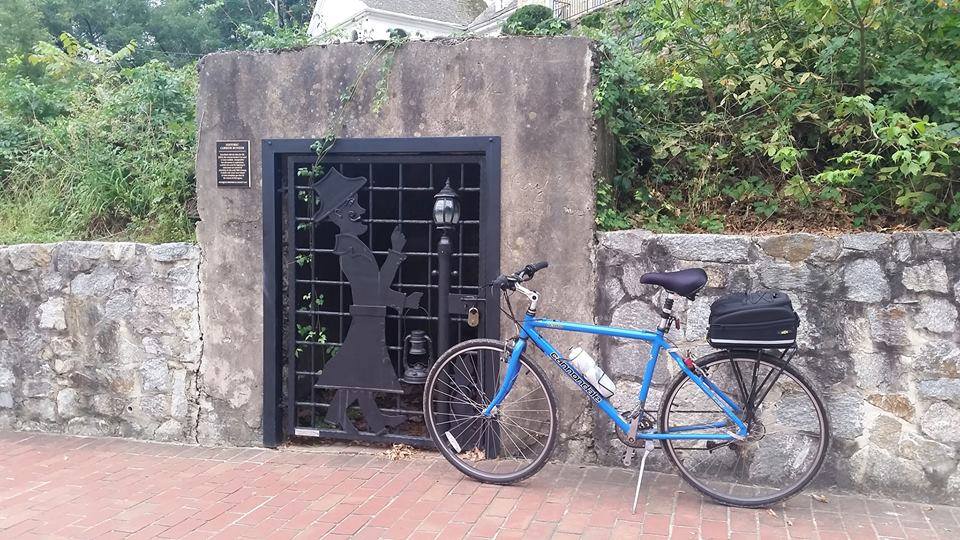
The Assassination Site of President Garfield

President James A. Garfield was the 20th president of the United States, serving from March 4, 1881, until his death by assassination six and a half months later while waiting to catch a train at the Baltimore and Potomac rail station.  The site where it happened s just a few hundred yards from the 20th President’s official Presidential Memorial in an area of the city that has gone through many changes since the train station’s building and tracks were demolished in 1908 during a redesign of the National Mall.  The National Gallery of Art’s West Building is now located there (MAP).  But one thing stayed the same at the site for the first 137 years after President Garfield’s assassination.  That was the absence of a plaque or historical marker to indicate what happened there on July 2, 1881.  But that recently changed.  So on this bike ride, I went there to see the new historical marker.

When President Garfield was elected in 1880, a man named Charles Julius Guiteau falsely believed he had played a major role in his victory.  He also thought he should be rewarded with a consulship for his efforts in electing the new President.  So he submitted applications to serve in Paris or Vienna, despite the fact he spoke no French or any other  foreign language.  But when the Garfield administration rejected his applications, he decided it was because he was part of the Stalwart faction of the Republican Party, and President Garfield was affiliated with the opposing Half-Breed faction of the party.  Guiteau was so offended at being rejected for a consular position that he decided President Garfield had to die so that Vice President Chester A. Arthur, who was a fellow Stalwart, would succeed him.  He thought this would not only end the war within the Republican Party, but would lead to rewards for fellow Stalwarts, including himself.

As difficult as it is to imagine in today’s political world, the assassination of President Abraham Lincoln was seen as a fluke due to the Civil War, and Garfield, like most people, saw no reason why the president should be guarded.  In fact, the President’s plans and schedule were often printed in the newspapers.  Knowing his schedule and where he would be, Guiteau followed Garfield several times.  But each time his plans to kill the President were frustrated, or he lost his nerve.  Then in the summer of 1881, when the President had been in office for only four months, Garfield decided to take a train trip to New England to escape the swampy summer heat of D.C.  Right after he arrived at the Baltimore and Potomac rail station, Guiteau emerged from where he had been hiding by the ladies’ waiting room and walked up to Garfield and shot him twice, once in the back and once in the arm, with an ivory-handled pistol, a gun he thought would look good in a museum.  Guiteau was quickly apprehended, and as he was led away, he stated, “I did it. I will go to jail for it. I am a Stalwart and Arthur will be President.”

The wounded President was taken upstairs to a private office in the train station, where several doctors examined him.  There they probed the wound with unwashed fingers, another thing that is difficult to imagine today.  At Garfield’s request, he was then taken back to The White House.  The physician who took charge at the train station and then at the White House was Willard Bliss, an old friend of the President’s.  About a dozen physicians, led by Dr. Bliss, were soon probing the wound, again with unsterilized fingers and instruments.

Although in considerable pain despite being given morphine, the President did not lose his sense of humor.  He asked Dr. Bliss to tell him his chances, which Bliss put at one in a hundred. The President then replied, “Well, Doctor, we’ll take that chance.”  In addition to his treatment, Garfield was also being given oatmeal porridge and milk from a cow on the White House lawn for nourishment.  However, he hated oatmeal porridge.  So when he was told that Indian chief Sitting Bull, a prisoner of the U.S. Army, was starving, Garfield initially said, “Let him starve,” but then quickly changed his mind and said, “Oh, no, send him my oatmeal.”

During the President’s treatment, Alexander Graham Bell attempted to locate the bullet with a primitive metal detector.  (The use of X-rays, which likely would have helped the President’s physicians save his life, would not be invented for another fourteen years.)  However, he was unsuccessful.  But they were able to help keep Garfield relatively comfortable in the stifling heat that he had been trying to escape with one of the first successful air conditioning units, which reduced the temperature in the sickroom by 20 degrees.

During the weeks of intensive care after being shot, Garfield would alternately seem to get better and then take turns for the worse.  He developed an abscess around the wound, which doctors probed but most likely only made worse.  He also developed infections that cause him to have a fever of 104 degrees, and he lost a considerable amount of weight.  Eventually, Dr. Bliss agreed to move him to Elberon, part of Long Branch, New Jersey, where his wife had been recovering from an illness at the time her husband was shot.

There, Garfield could see the ocean as officials and reporters maintained what became a death watch. Garfield eventually succumbed to a combination of his injury and his treatment.  On September 18, Garfield asked Almon Ferdinand Rockwell, a friend and business associate who was at his bedside, if he would have a place in history. Rockwell assured Garfield he would, but told him that he still had much work to do.  The President responded, “No, my work is done.”  He died later that night.

According to many medical experts and historians, Garfield most likely would have survived his wounds had Dr. Bliss and the other doctors attending to him had the benefit of modern medical research, knowledge, techniques, and equipment.  In fact, much like President Ronald Reagan after the assassination attempt at The Washington Hilton here in D.C., Garfield would probably also have survived being shot.  Instead, the treatment he received at least contributed, and most likely caused his death.  It is thought that starvation also played a role in President Garfield’s death.

Four presidents have been assassinated while in office.  And two of them occurred here in D.C.  President Lincoln was killed at Ford’s Theater in 1865, and just 16 years later President Garfield was shot by Guiteau less than a thousand yards away from where President Lincoln was shot by John Wilkes Boothe.  There were already official markers for President Lincoln at The Petersen House in D.C. where he died, President William McKinley in Buffalo, New York, and President John F. Kennedy in Dallas, Texas.  Now all four sites have been properly recognized.  I’ve now been to the two sites here in D.C.  The other two, however, are a little too far away for a lunchtime bike ride.


[Click on the photos to view the full-size versions]

ASA01

Observing Ascension Day at The Church of the Ascension and Saint Agnes

Today is Ascension Day, a Christian celebration day commemorating Jesus’s ascension into heaven.  According to the Bible, Christ met several times with his disciples during the 40 days after his resurrection to instruct them on how to carry out his teachings. It is believed that on the 40th day he took them to the Mount of Olives, where they watched as he ascended to heaven.  Therefore, Ascension Day occurs ten days before Pentecost and is observed on the 40th day of Easter, which always falls on a Thursday.  However, some churches, particularly in the United States, celebrate it on the following Sunday.

In observance of Ascension Day, on this lunchtime bike ride I stopped by the Church of the Ascension and Saint Agnes, located at 1215 Massachusetts Avenue (MAP) in the Downtown neighborhood of northwest D.C.

The origin of the Church of the Ascension and Saint Agnes dates back to May 7, 1844, when several people who had previously attended services at nearby St. John’s Episcopal Church, Lafayette Square met to discuss establishing their own parish.  After approval from the diocese, the territory of St. John’s was split between the two churches, formally establishing the Church of the Ascension on March 1, 1845.

After the donation of land on H Street, between 9th and 10th streets, by Parishioner Martha Burnes Van Ness, a prominent local socialite and the wife of banker and future D.C. Mayor John Peter Van Ness, the cornerstone was laid for the church’s new home on September 5, 1844.  Construction of a the Gothic Revival brick building was complete enough to use by December 1844, and the first services were held on December 14th.

During the Civil War there were disagreements within the church. with some parishioners as well as clergy sympathizing with the Confederacy while others were Unionists.  After one such disagreement in which the parish’s bishop asked the church to pray and thank God for recent Union victories and the church’s rector refused, Washington’s Provost Marshall notified the church that the authorities would assume control of the church to prevent a disturbance.  The Church of the Ascension then became a military hospital to house casualties from the war, as did Church of the Epiphany, and Holy Trinity Catholic Church in Georgetown.

During the subsequent war years after their church was seized by the government, the parish was without a home. The problem was solved by member William Corcoran, a prominent banker and partner in the firm of Corcoran and Riggs, later known as Riggs Bank. Corcoran offered the use of a building he owned on H Street, between 13th and 14th Streets.  The congregation met there, and would not return to its permanent home until after the conclusion of the war more than three years later.

Within a short period of time after the congregations return to the church, the structure proved too small and not grand enough for what was now one of the most affluent areas of the city.  So after much debate, church leaders decided to erect a new structure. William Corcoran donated the site at the northwest corner of Massachusetts Avenue and 12th Street where the church continues to be located, as well as approximately half of the $205,000 construction costs.

The cornerstone for what is still the church’s current building was subsequently laid on June 9, 1874.  The building is constructed of white marble quarried near Cockeysville, Maryland, with accents of pink Ohio sandstone.  Designed in the Victorian Gothic style, it reaches a height of 74 feet with a 190-foot tower and spire that was visible across much of the city at the time it was built.

After World War I, membership at the Church of the Ascension began to decline, and in 1925 the congregation merged with nearby St. Stephen’s Church to help stabilize the parish.  This worked briefly until the onset of the Great Depression, when a downturn began that lasted through 1947, when the diocese considered selling the building to another congregation.  It was then that the Vestry received a proposal from St. Agnes Episcopal Church to merge.  It accepted and adopted its present name, under which its diverse, urban congregation continues as an active parish in the Episcopal Diocese of Washington.

ASA02     ASA04     ASA03

ASA05     ASA06     ASA07

ASA06a     ASA07a     ASA12

ASA08     ASA09   ASA11
[Click on the thumbnails above to view the full size photos]

wilkesstreettunnel01

Wilkes Street Tunnel

During all of my lunchtime bike rides over the past several years I have been able to enjoy hundreds of aspects of the city and surrounding area.  From monuments and memorials to churches and cemeteries, there is always something interesting to discover and learn about.  But on this ride I happened upon something that up until this point I had not seen before.  As I was riding in Old Town Alexandria I happened upon an old underground tunnel.

Located near the eastern end of Wilkes Street (MAP), with an entrance to the west of Windmill Hill and Shipyard Parks, it turns out that it is the Wilkes Street Tunnel, which originally was a railroad tunnel used by Union troops during the Civil War to ship supplies from Alexandria to Richmond and points south.  And I didn’t even have to wait until after my ride to learn about it because there is a plaque on the wall at the western end of the tunnel that provides its history.

The plaque reads, ” The Wilkes Street Tunnel was part of the Orange & Alexandria Railroad, founded in 1848 to promote trade with western Virginia. The Orange and Alexandria inaugurated its track in Alexandria on May 7, 1851 with a run to the north end of Union Street to the Wilkes Street Tunnel. Thus, the tunnel linked the railroad to warehouses and wharves along the waterfront. Located nearby, the Smith and Perkins foundry manufactured locomotives for the Orange and Alexandria and other railroads.

Wilkes Street Tunnel is typical of cut-and-cover tunnel construction. Presumably, the tunnel was cut through the bluff overlooking the Potomac River and covered to continue the streets above. After the sides were built up with stone, the arch probably was constructed over wood falsework from both sides using a centering technique to form the brick barrel vault. The tunnel was deepened after World War I to accommodate higher boxcars.

The Orange and Alexandria line was one of the many Alexandria railroads taken over by Union forces at the onset of the Civil War. While this northerly section of the railroad was incorporated into the U.S. Military Railroads, the length of track south of the Rappahannock River remained in Confederate hands.

Both sections played an major role in the strategies of North and South, as well as a decisive element in the Confederate victory at the Second Battle of Manassas or Bull Run. The Wilkes Street Tunnel gave Union Army access to the wharves for shipping military supplies on car ferries south of Aquia Creek, terminus of the Richmond, Fredericksburg & Potomac Railroad.

Shortly after the Civil War, the old Orange & Alexandria line was incorporated into the Washington City, Virginia Midland & Great Southern Railway controlled by the Baltimore & Ohio Railroad. Wilkes Street Tunnel played a part in the rivalry between the Baltimore & Ohio and Pennsylvania Railroads for supremacy in the north-south trade across the Potomac River. The Pennsylvania Railroad acquired Congressional authorization for exclusive use of Long Bridge (14th Street). To maintain a competitive position, Baltimore & Ohio offered trans-Potomac service by way of carfloats linking Wilkes Street with Shepherd’s Ferry on the Maryland shore until about 1906.

The Wilkes Street track continued in operation until 1975 when declining industrial activity along the waterfront no longer warranted rail service. The tunnel is significant today as Alexandria’s only 19th century transportation site surviving intact.”

The interior of the tunnel consists of dry-laid grey sandstone vaulted walls.  Its dimensions are approximately 170 feet long with exterior stone and brick surfaces, and an interior consisting of grey sandstone masonry, with a 15-foot deck and an arch with a vertical clearance of 17 feet.  The city completed a structural refurbishment of the tunnel in March of 2008, and a ribbon-cutting ceremony was held on March 11th.  Today the tunnel is open to pedestrians and bike riders like me.

wilkesstreettunnel02

occoquan01

The Historic Town of Occoquan

With traffic and transit changes anticipated in D.C. because of the long Columbus Day holiday weekend, for this bike ride I chose to go outside of the city.  For this excursion I chose the historic town of Occoquan, located approximately 23 miles south of D.C. in Prince William County, Virginia (MAP).  It is situated on the south bank at the fall line of the Occoquan River, and directly across the river from the Occoquan Regional Park and the Lorton Correctional Facility Beehive Brick Kiln.  With access available via road, river and the East Coast Greenway, it is accessible by car, boat, foot traffic, and by bike.

The town derives its name from an Algonquian Doeg Indian word, meaning “at the end of the water”.  And throughout its existence the river has been its lifeblood.  It was its location on the water which attracted and then sustained its original occupants, indigenous people who relied upon the river for fish and sustenance.  Similarly, for the British and subsequently American colonists who came after them, the river provided an ideal site to for transportation and trade.   A tobacco warehouse was built as early as 1736, and an industrial complex began in 1750.  Within the next several decades Occoquan had iron-manufacturing, a timber trade, quarrying, river-ice, shipbuilding, a bake house, saw mills, warehouses, and Merchant’s Mill, the first automated grist mill in the country.  It operated for 175 years until destroyed by fire.  Later, during the Civil War, the Occoquan Post Office passed letters and packages between North and South.  But eventually river silting and the shift in traffic to railroads reduced ship traffic to Occoquan and ended its days as a port.

Reflecting the rich history of Occoquan, a number of structures in town, including a number in the downtown commercial area, are part of the Occoquan Historic District which is listed on the National Register of Historic Places.  One of the more prominent examples of these structures is Rockledge, the former house of the town’s founder, which sits on an overlook above the town.

But the town has not only survived.  It has thrived.  Today, it is a restored artists’ community, with an eclectic collection of over one hundred specialty shops offering everything from antiques, arts, crafts, fashions, to unique gifts.  The town also offers a public park complete with a gazebo, a town boat dock, a museum, guided ghost walks, and a full array of dining choices, from ice cream and snack stands to a five star restaurant.  And everything is within walking distance, with much of it adjacent to the river.

It was still dark when I arrived this morning, but I found a place named Mom’s Apple Pie Bakery that was already open.  So I indulged in a piece of Shenandoah Peach Pie, which I took down to the waterfront and enjoyed for breakfast as the sun was coming up.  I also purchased a jar of locally-made fresh pumpkin butter to take home.   The bakery, the riverfront, and the entire town were all fun to explore, and a great way to begin Columbus Day, named after a great explorer.

occoquan00     occoquan03     occoquan02

occoquan10     occoquan11     occoquan12

occoquan13     occoquan04     occoquan07

occoquan06a    occoquan05    occoquan09a    occoquan08

occoquan14     occoquan15     occoquan16

occoquan18     occoquan19a     occoquan20

occoquan17
[Click on the photos to view the full-size versions]

lakeaccotink20a

Lake Accotink Park

Long holiday weekends are always a great opportunity to venture outside of the city and go for a bike ride in one of the many nearby state, regional, or county parks and recreation areas.  And on this early-morning, holiday weekend ride I rode the bike trail that goes around the lake at Lake Accotink Park, which is a multi-purpose park located at 7500 Accotink Park Road (MAP), just outside of D.C. in North Springfield, Virginia.  

Lake Accotink is a reservoir in eastern Fairfax County, Virginia, which is formed by the damming of Accotink Creek. The 55-acre park surrounding the lake is maintained by the Fairfax County Park Authority.  But the park was severely damaged not too long ago by flooding in the area.  And although evidence of the damage can still be seen, the trails are usable again.

Running through the park is a trestle bridge for the Orange and Alexandria Railroad, which was an intrastate railroad in Virginia.  The railroad extended from Alexandria to Gordonsville, with another section from Charlottesville to Lynchburg.  The railroad played a crucial role in the Civil War, and eventually became an important part of the modern-day Norfolk Southern rail system.

A sign near the bridge reads, “The original bridge crossing the Accotink Creek was built in 1851 as part of the Orange and Alexandria Railroad. During the Civil War the wooden trestly was an attractive target for Confederate soldiers. In his 28 Dec 1862 raid on Burke’s Station, Confederate Major General J.E.B. Stuart sent twelve men to burn the trestle. Although termed an “inconsiderate structure” by the Union press, the raid was alarming to many because of its close proximity to Alexandria. The trestle was quickly rebuilt, allowing the Union to continue transporting vital supplies along the line for the remainder of the war.” 

The park also has canoes, paddleboats, and rowboats available for rent.  Visitors can also take a tour by boat.  The park’s trail loop around the lake is a multi-use trail that accommodates bikes, as well as walkers and runners.  And there are other trails that stretch beyond the park and connect to the Cross-County Trail, with its running trails and mountain biking trails.  There is also a miniature golf course and an antique carousel near the south entrance to the park.

Accotink Park was one that I had not been to before, and I very much enjoyed the parts of the park that I saw.  However, it is so big that there are still more parts to explore.  So I guess I’ll just have to go back again soon.

Accotink09     Accotink08     Accotink010

LakeAccotink21     LakeAccotink22     Accotink02a

LakeAccotink26     LakeAccotink25     Accotink02

Accotink03a     LakeAccotink28     Accotink07

Accotink01a     LakeAccotink31     LakeAccotink29
[Click on the photos above to view the full size versions]

LincolnSummerHouse01 (3)

President Lincoln’s Cottage

On this lunchtime bike ride I visited what’s now known as President Lincoln’s “cottage”, which is a national monument located on the grounds of the “Old Soldiers’ Home,” known today as the U.S. Soldiers’ and Airmen’s Home.  Located in northwest D.C. near the Petworth and Park View neighborhoods (MAP), the Gothic Revival-style residence, a style considered particularly appropriate at that time for country cottages, has a very interesting history.

Originally known as the “Corn Rigs” cottage, it was built in 1842 by wealthy D.C. banker George Washington Riggs, at his 250-acre summer retreat.  The word “cottage”, however, is somewhat of a misnomer inasmuch as it is actually a 34-room country home.  Almost a decade later, Riggs offered to sell his property to the Federal government, which was looking for a place to create a home for retired and disabled Army veterans.  An army committee purchased the estate in 1851 and utilized the house to create the Old Soldiers’ Home later the same year.  Six years later, in 1857, the retired soldier residents moved into a newly-built large stone Gothic building near the cottage. 

With the cottage now vacant, the Old Soldiers’ Home invited President James Buchanan to make his summer residence there.  Accepting the offer, President Buchanan spent a few weeks out of at least two summers at the cottage during the remainder of his presidency.

Presumably on the recommendation of President Buchanan, the next president, Abraham Lincoln, first visited the Old Soldiers’ Home just three days after his first inauguration.  Later, President Lincoln and his family would escape to the cottage between June and November in 1862, 1863, and 1864.   The family would almost certainly have returned in 1865 if President Lincoln had not been assassinated in April of that year.  In all, President Lincoln and his family spent over a quarter of his Presidency there. Each summer The White House staff transported some 19 cartloads of the Lincoln family’s belongings to the cottage. Unfortunately, there is no record of exactly what they brought.

With the Civil War officially commencing just a month after he was inaugurated, Lincoln could not escape the Civil War and his burden of leadership, even at the cottage. Every morning the President rode by horseback to the White House to carry out official business, returning to the cottage every evening.  Today, the drive down Georgia Avenue takes just a few minutes, but in the 1860s the commute through what was then a mostly wilderness area was a little slower and more dangerous.  The cavalry units that were to eventually accompanied him on his commute, as well as the encampments, hospitals, and cemeteries he passed on his was to work served, as constant reminders of the war.

It was while staying at the cottage, in fact, that President Lincoln came his closest to the war.  On July 12, 1864, when Confederate General Jubal Early attacked Fort Stevens, the President brashly went to observe the nearby battle, even though his family had been evacuated to the White House for the four days of the battle.  It was during this time that President Lincoln became the only president ever to come under hostile fire while in office.  During the second day of the battle, as he stood on atop the parapet of the fort to witness the battle, the President came under direct fire of Confederate sharpshooters.  Perhaps saving his life, a young officer named Oliver Wendell Holmes, Jr., who would eventually go on to serve as a justice on the U.S. Supreme Court, shouted to the President, “Get down, you damn fool!”

Other interesting events for which President Lincoln’s cottage served as the backdrop include the fact that the President was staying at the cottage when he wrote the final draft of the Emancipation Proclamation in September of 1862.  And in August of 1864, a sniper attempted to assassinate the President as he traveled back to the cottage alone late at night.  The lone rifle shot missed Lincoln’s head by inches, but during the attempt the President lost the hat he was wearing.  The following day, two soldiers went looking for the hat.  They discovered it on the path, with a bullet hole through the side.  Also, in the summer of 1864, John Wilkes Booth, who would later in April of 1865 successfully assassinate President Lincoln, formulated his original plot, which was to kidnap the President during his commute from the cottage to the White House.

President Lincoln reportedly made his last visit to the cottage on April 13, 1865, the day before his assassination.  But he was not the last president to take advantage of the healthy breezes at the cottage.  Rutherford B. Hayes spent the summers of 1877 to 1880 there.  And Chester A. Arthur stayed at the cottage during renovations at the White House in the winter of 1882, and spent summers there as well.

In more recent years, the cottage has been recognized for its historical significance. The Secretary of the Interior designated the U.S. Soldiers’ and Airmen’s Home, which includes the pre-Civil War cottage, as a National Historic Landmark in November of 1973.  President Bill Clinton declared the cottage and 2.3 surrounding acres a National Monument in July of 2000.  To this day it holds the distinction of being the only national monument in the country that operates with no Federal funding.  The following year, the National Trust for Historic Preservation began a thorough restoration of the cottage, restoring it to the period of Lincoln’s occupancy according to standards established by the National Park Service. The restoration was completed in 2007.  President Lincoln’s Cottage was then opened to the public for the first time in history on President’s Day in 2008. It remains open today, and is managed through a cooperative agreement between the Armed Forces Retirement Home and the National Trust for Historic Preservation.

LincolnSummerHouse01 (2)     LincolnSummerHouse01 (4)
[Click on the thumbnails above to view the full size photos]

LincolnCottageTour

Click on this photo to take a virtual tour of the inside of The Lincoln Cottage.