Posts Tagged ‘Maryland’

BattleOfBladensburg01

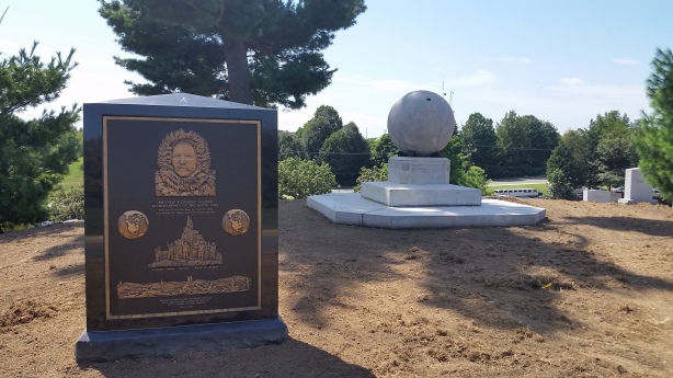
Battle of Bladensburg Marines Memorial

By the end of this long leisurely ride, or I should say the halfway point since I still needed to ride back to where I started, I found myself in Prince George’s County, Maryland.  As I rode around taking in the area, I came upon Fort Lincoln Cemetery, and realized I had been here before.  Located at 3401 Bladensburg Road in Colmar Manor, Maryland (MAP), I had previously discovered a number of historic sites on the cemetery grounds.  These sites include Historic Fort Lincoln and The Old Springhouse, as well as the nearby Bladensburg Dueling Grounds, located just outside of the cemetery.  With so many points of interest in the area, I decided to conduct some additional exploration and see what else I could find.  And I wasn’t disappointed.  

While riding around the expansive grounds within the cemetery, I saw what looked like a seating area behind the building with the mausoleum, which happens to be one of the grandest public mausoleums in the world.  It is very large, open to the public, and contains a beautiful garden.  So I decided to ride over to the seating are and take a break to relax.  But as I got there and upon closer inspection I found out that it was, in fact, a memorial rather than just a place to sit.  A stone marker at the entrance to the memorial reads, “This is the site of the Battle of Bladensburg. It was here that Commodore Barney and his marines were defeated in the War of 1812. The British moved on to burn the Capitol and White House.”  I quickly pulled up some information on my cellphone.  But naturally I was anxious to do more research and learn al about it later after I got home.  

I learned that the Battle of Bladensburg was part of what was known as the Chesapeake Campaign of the War of 1812.  As an aside, I have always the name odd inasmuch as the War of 1812 was fought over a nearly three-year period.  Anyway, caused by British restrictions on U.S. trade and America’s desire to expand its territory, the United States took on the greatest naval power in the world, Great Britain.  

Although neither side had gained a clear advantage in the first two years of the war, that changed in the spring of 1814 when Britain was able to disentangle itself from fighting France in the Napoleonic Wars.  After Napoleon Bonaparte’s exile in April 1814, British forces in the war with America could now be replenished with thousands of veterans. These soldiers were different than the soldiers Americans had faced in Upper Canada; these men had fought against Napoleon and his Imperial Guard and wanted a quick end to this war against a young country.  

The Battle of Bladensburg was fought on August 24, 1814, and America lost.  And in large part due to the fortification of British forces with combat-experienced veterans, it was a significant loss for America.  The defeat of General William Henry Winder and the 6,500 American men he had at his disposal allowed British Army Officer Robert Ross and his 4,500 men to subsequently march into nearby D.C.

President James Madison and his cabinet had already fled the city at that point, with Dolly Madison and White House slave Paul Jennings famously saving critical relics of their new republic, among them a portrait of George Washington.  And it was a good thing that they did because the British promptly set fire to the city’s public buildings, including the presidential mansion (later to be rebuilt and renamed as The White House) and the U.S. Capitol Building over the following couple of days.  The loss at the Battle of Bladensburg to a smaller but superior fighting force and the subsequent destruction of these symbols of American democracy devastated the morale of both American servicemen and the the public, and almost lead to the complete military defeat of the young American nation.    

Ultimately, the War of 1812 ended in a draw on the battlefield, and the peace treaty reflected this. The Treaty of Ghent was signed in modern-day Belgium on December 24, 1814, and went into effect on February 17, 1815, after both sides had ratified it.  And while Britain effectively won the War of 1812 by successfully defending its North American colonies, America also succeeded in not only maintaining it’s independence but expanding both U.S. trade and its territory as the country grew westward.  

So who was the Commodore Barney mentioned on the inscription at the memorial?  Joshua Barney was an American Navy officer who served in the Continental Navy during the Revolutionary War who later achieved the rank of commodore in the United States Navy.  During his service in the War of 1812 he commanded the Chesapeake Bay Flotilla, a fleet of gunboats tasked with defending Chesapeake Bay.  Concerned that Barney’s flotilla could fall into British hands, Secretary of the Navy John Paul Jones ordered Barney to take the flotilla as far up the Patuxent River as possible, to Queen Anne, and scuttle it if the British appeared.  Leaving his barges with a skeleton crew to handle any destruction of the craft, Barney took the majority of his men to join the American Army commanded by General  Winder where they participated in the Battle of Bladensburg.  

Subsequent to narrowly avoiding capture prior to the battle, President James Madison personally directed the Marines led by Barney, making the Battle of Bladensburg one of only two instances of a sitting president exercised direct battlefield authority as Commander-in-Chief.  The other was when George Washington personally crushed the Whiskey Rebellion.

Commodore Barney was severely wounded during the Battle of Bladensburg, receiving a bullet deep in his thigh that could never be removed.  He later on December 10, 1818, from complications related to the wound. His remains rest in Allegheny Cemetery in Pittsburgh.

I find it unusual that a memorial was built about what was a disastrous defeat for the United States.  But considering the dedication and bravery of men like Commodore Barney and the marines and other men who fought in that war, I think a memorial to them is fitting despite the loss at the Battle of Bladensburg.   

BattleOfBladensburg04     BattleOfBladensburg03
[Click on the photos to view the full-size versions]

NOTE:  The historic marker (see photo above) reads:  “This is the site of the Battle of Bladensburg which took place in the War of 1812.  Joshua Barney and his 500 marines were greatly outnumbered by the British expeditionary force of 4,500 trained regulars. The battle raged for four hours but eventually the overpowering numerical odds won out for the British who went on to burn the Capitol and the White House. On this location, Commodore Barney was wounded and taken prisoner. This memorial is in honor of Commodore Joshua Barney who made the supreme sacrifice in defense of his country and to his detachment of marines for their distinguished display of valor and gallantry.”  

NOTE:  The Battle of Bladensburg Marines Memorial is different than the more famous Battle of Bladensburg Memorial, which is located at the battlefield, that has been preserved under the Prince George’s County Department of Parks and Recreation, and is located in Waterfront Park, down the street  between the Bladensburg Peace Cross and the George Washington House (two places I plan to ride to someday soon), at 4601 Annapolis Road in Bladensburg.  

Peary02

Matthew Alexander Henson Memorial

Robert Edwin Peary Sr. was an American explorer who made several expeditions to the Arctic in the late 19th and early 20th centuries, and is best known for claiming to be the first expedition to reach the geographic North Pole.  But why mention Perry?  After all, the memorial I visited on this bike ride is dedicated to Matthew Alexander Henson.  Henson, also an American explorer, accompanied Peary on seven voyages to the Arctic, including the famous 1908-1909 expedition that claimed to have reached the geographic North Pole on April 6, 1909.  The expedition party consisted of Perry, Henson and four Inuit assistants.  And Henson said he was the first individual of their expedition party to reach the pole.

Henson was born in Nanjemoy, Charles County, Maryland, on August 8, 1866, to sharecropper parents who were free Black Americans before the Civil War.  He spent most of his early life here in D.C., but left school at the age of twelve when both of his parents died.  He then went to work as a cabin boy on a merchant ship, having been fascinated by stories of the sea.  He learned to to read, write and navigate while working on the ship.  But at the age of 18 he returned to D.C. and worked as a salesclerk at a hat shop. It was there that he met a customer named Robert Peary, who in 1887 hired him as a personal valet.

Their first Arctic expedition together was in 1891–92. Henson served as a navigator and craftsman, and was known as Peary’s “first man”. But it was during their 1908–09 expedition to Greenland, that Peary and Henson, along with four Inuit assistants, claimed to have been the first to reach the geographic North Pole.  In interviews, Henson identified as the first member of the party to reach the pole.

Henson achieved a level of fame from his participation in the expedition, and in 1912 he published a memoir entitled “A Negro Explorer at the North Pole”.  As he approached old age, his exploits received renewed attention, including being received at the White House by Presidents Harry Truman and Dwight Eisenhower.

Eighty years later, and decades after Henson’s death, a research paper by an English explorer named Wally Herbert claimed that their expedition records were unreliable, and indicated a that the men could have fallen 30–60 miles short of the pole due to navigational errors.  Nonetheless, Peary and Henson and the expedition has remained famous as one of the great explorations of history.

Henson died on March 9, 1955, at the age of 88, and was buried at Woodlawn Cemetery in the Bronx, New York.  He was survived by his second wife Lucy Ross Henson. After her death in 1968, she was buried with him. But in 1988, both their bodies were moved and reintered during a commemoration ceremony at Arlington National Cemetery.  And that is where I rode on this bike ride to see his memorial.

The memorial at his gravesite features an inset bronze plaque commemorating the North Pole discovery.  At the top sits a large bas-relief bust of Henson in Arctic gear.  Immediately below, an inscription describes his part in reaching the North Pole. And globes of the world, tilted with the Pole in view, sit at either side.  The central image, which was based on a photograph that Peary took at the Pole on April 6, 1909, shows Henson flanked by the four Inuit assistants with the U.S. flag flying behind them atop a mound of ice. The bottom panel on the memorial depicts dogsleds and dramatic ice floes, suggestive of the struggle that Henson, Peary and the Inuit sustained over many years to achieve their goal.  And on the opposite side, an inscription quotes Henson’s book, “A Negro Explorer at the North Pole.” It reads, “The lure of the Arctic is tugging at my heart. To me the trail is calling! The old trail. The trail that is always new.”

Peary03     Peary04
[Click on the thumbnails above to view the full size photos]

NOTE:  The monument in the background of the photo at the top is dedicated to Peary.  I will go back to visit it and write about him at some point in the future.

32839174_10213448679144086_6051075592500019200_o

This Year’s Soggy National Bike to Work Day

The month of May is National Bike Month, May 14 through 18, 2018 is Bike to Work Week, and today was Bike to Work Day. And although it hasn’t been raining all month, it has been raining all week. And it continued to rain all day today. But Bike to Work Day is a rain or shine event, but that didn’t stop this morning’s Bike to Work Day event, which went on more or less as planned.

The League of American Bicyclists began Bike to Work Day as part of Bike Month in 1956. Over the years, Bike to Work Day has grown into a widespread event with countless bicyclists taking to streets and trails nationwide in an effort to get commuters to try bicycling to work as a healthy and safe alternative to driving a car. In the greater D.C. region, Bike to Work Day has grown from a small group of a few hundred in 2001 to more than 18,700 participants last year.  This year’s event was coordinated locally by Commuter Connections and the Washington Area Bicyclist Association (WABA) . And even more riders were expected to participate this morning.

Each year WABA, along with local bike shops and organizations, sponsor 100 pit stops along many of the commuter routes in D.C., Maryland and Virginia. The pit stop which I signed up for was to be located at Freedom Plaza, the same pit stop where I’ve stopped for the last several years.  But due to the rain it had to be moved across the street and inside to the lobby of the National Theater, located at 1321 Pennsylvania Avenue (MAP).  I also rode by some of the other pit stops.  They were a little less crowded than previous years’ pit stops have been, but I was able to pick up my free T-shirt, as well as have a nice breakfast of a breakfast burrito, a fresh banana, and a bottle of pomegranate blue acai juice.   They also were handing out other fresh fruit, granola bars, locally-baked bagels, and various other snack items. They also gave away other free items like water bottles, sunglasses, tire repair kits, bike lights and bells, area maps, etc.  And by signing up and stopping at the pit stop I was also entered into a raffle for a new bike.  So the pit stop all served their purpose, including the indoor one, even if I didn’t win the new bike.

         
[Click on the thumbnails above to view the full size photos]

Related Links:

Walking a Labyrinth for World Labyrinth Day

Starting in 2009, The Labyrinth Society designated the first Saturday in May, which this year falls on May 5th, as World Labyrinth Day.  And although that is not until tomorrow, during today’s bike ride I decided to stop and walk the labyrinth located in the sanctuary of The Church of The Epiphany, which is open to the public Monday through Friday from 10:00am until 3:00pm.

At different times, the practice of walking a labyrinth has been associated with pilgrimages and pagan rituals.  More recently however, labyrinths have popped up in modern spirituality for contemplation and as prayer.  People walk a labyrinth for as many reasons as the number of people who walk one, including centering, feeling grounded, as prayer, as meditation, or as a great way to just unwind and clear your mind.

If you would like to walk a labyrinth tomorrow to celebrate World Labyrinth Day, there are nine labyrinths here in D.C., and more than a dozen more now exist within a ten-mile radius of the city.  Of these, there are at least a half a dozen outdoor labyrinths that are open to the public, and most are open daily from sunrise to sunset or shortly thereafter.

One of a few local labyrinths located outdoors and available to the public, the Georgetown Waterfront Park Labyrinth provides a means to walk a labyrinth in a scenic location.  It is located at the southern end of 33rd Street (MAP) in northwest D.C.’s Georgetown neighborhood.

The American Psychological Association also has a labyrinth on the green rooftop of their building at 10 G Street (MAP), near Union Station in northeast D.C.’s NoMa neighborhood.  The 42-foot labyrinth features trellises, plantings, tables, a journal, and a finger labyrinth that you can “walk” with your fingers—a good option for those with ambulatory issues. It is open Monday through Friday from 7:00am to 7:00pm.  You can sign in at the building’s security desk to go up to the roof, or call Holly Siprelle (202-336-5519) to arrange a guided walk.

There is also an outdoor labyrinth that is available to the public at Barton Park, located across the river at the corner of North Barton and 10th Streets (MAP) in Arlington, Virginia.  Originally part of the former Northern Virginia Whitman-Walker Clinic’s healing garden, the 37-foot labyrinth of precast stone and pavers went into storage when that branch of the clinic closed.  It was later moved to Barton Park in late 2013.

Set among old pines and other trees, St. Aidan’s Episcopal Church in Alexandria, Virginia, also has a public labyrinth.  Located at 8531 Riverside Road (MAP), the 40-foot labyrinth is made of rubber mulch with white stones outlining the path and is set near a memorial garden with benches. At the nearby Art at the Center, parishioner Kathryn Horn Coneway offers workshops on making finger labyrinths from clay.

The city of Bethesda’s St. Luke’s Episcopal Church, located at 6030 Grosvenor Lane (MAP), has a 62-foot labyrinth made from turf and pavers, as well as a 36-by-36-inch Plexiglas finger labyrinth, available to the public.  At this labyrinth, a journal to record your thoughts is available, and is located under the bench.

The University of Maryland’s Garden of Reflection and Remembrance, located at 7600 Baltimore Avenue in College Park (MAP), also has a labyrinth adjacent to the campus chapel. Guided walks, yoga sessions, and special events are regularly scheduled. Benches, trees, and water elements help visitors connect with nature.

If you want to walk a labyrinth, but these options are not readily available to you, I encourage you to find one that is.  To find others labyrinths here in the D.C. area, or anywhere else in the world, just use the Labyrinth Society’s online worldwide labyrinth locater.  And if there is not a labyrinth near you, there are also finger labyrinths now available as a smartphone app.  Just check the Google Store or iTunes.

         
[Click on the photos to view the full-size versions]

An Anniversary of Sorts

Posted: April 25, 2018 in Events
Tags: , ,

An Anniversary of Sorts

Today is the anniversary of the first time I went for a bike ride during my lunch break at work.  Although it’s only been a little more than four years that I’ve been writing this blog about the places where I go and the things I see during my lunchtime bike rides , I went on my first lunchtime bike ride seven years ago today.  And around 1,400 rides and approximately 20,000 miles later, it’s still just as much fun as it was that first day in 2011.

That initial ride, on a bike I bought from a seller who listed it for sale via Craigslist, was not a particularly long one.  From my downtown office I rode to the National Mall, where I entered it at 9th Street.  Then on one of the gravel paths I rode down past The Washington Monument. I then rode over to the Jefferson Memorial, followed by a trip around The Tidal Basin.  Then I rode by the Bureau of Engraving and Printing and the Holocaust Museum.  Next I rode by the Smithsonian Castle and the National Sculpture Gardens.  Finally, I rode past the Air and Space Museum, the U.S. Capitol Building, and up through Embassy Row, before heading back to my office.  I remember at the time it sounded like an itinerary of a good week for a tourist.

Since that first bike ride I have had a number of different bikes I’ve kept at the office for my lunchtime rides.  I’ve ridden on days when the temperatures were in the 90’s, as well as days when the temperatures in the single digits.    I’ve ridden in the rain and the snow.  I have gone for rides in every neighborhood throughout the city, as well as to places in both Maryland and Virginia.  But there are still more than enough destinations to keep me riding for the foreseeable future.  In fact, I will probably retire before I run out of destinations for my lunchtime rides.  But even after I retire, I’ll still be riding.  Probably even more than I do now.

The District Boundary Stones

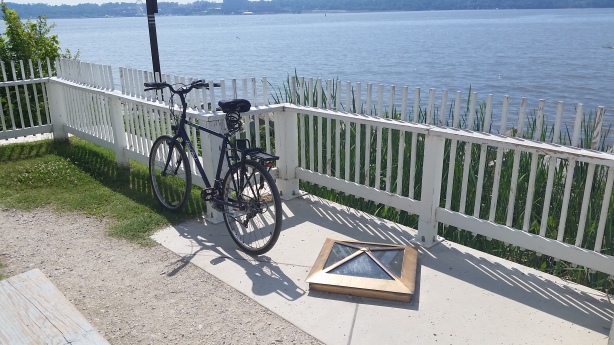
As I often say, there is history all around you if you just know how to look for it.  And that is particularly true in the D.C. area.  On this bike ride back to the Jones Point Lighthouse (MAP), I came across a brass-lined window in the floor of the lighthouse’s front porch.  Looking through the murky glass I saw a worn and weathered stone marker which was partially underground near the shore of the Potomac River.  It looked like it could be a grave’s headstone.  But the shoreline seemed like an odd place to bury someone.  So I decided to look into it.  And when I did I learned some more local history that dates back well over 200 years.

What I came across was what some people refer to as one of our country’s first Federal monuments — a District Boundary Stone.  In 1791, at the behest of President George Washington, 40 boundary stones were set in place to designate the original physical boundary of the nation’s new capital city.

Of course the city’s boundary has since changed.  Land from both Virginia and Maryland was ceded in 1790 to form the District of Columbia.  But in 1846, the area of which was ceded by Virginia was returned, leaving the territory originally ceded by Maryland as the current area of the District in its entirety.  But amazingly, 36 out of the original 40 stones still exist today, although some are now in Virginia.  The other four stones are replicas, such as NE1 which was demolished by a bulldozer  or SW6, which was smashed by a car.

Some of the stones are well cared for, such as the original West Boundary Stone, which now sits in Benjamin Banneker Park in Falls Church, Virginia (not to be confused with the Benjamin Banneker Park in D.C.), and is surrounded by a five-foot fence installed by the Daughters of the American Revolution.  Others are not as fortunate, such as NE3, which sits at New Hampshire Avenue, Eastern Avenue and Chillum Road in northeast D.C., surrounded by trash at the edge of a McDonald’s parking lot.  The stone known as S1, the one at Jones Point, is in relatively good shape.

So, the Boundary Stones are federal monuments.  However, they are not treated like any other federal monuments.  For the District, the stones are ostensibly owned by the District Department of Transportation, but the ground they sit on is owned by the National Park Service.  Of the stones located on the land that was retroceded to Virginia, many of the stones sit in people’s yards, and the private citizens own the land on which they sit.  Others are in municipal parks or cemeteries.  But regardless of who owns the land on which they are located, the stones remain Federal property.  And the fencing that surround some of them are owned and maintained by volunteer organizations.

Eventually, I would like to see and photograph all of the Boundary Stones.  And a good way to do this would be participating in the next Boundary Stone Bike Ride, an annual event sponsored by the Boundary Stone Public House in the northeast D.C.’s Bloomingdale neighborhood.  Participants can ride one, two, three or all four sides of the original D.C. perimeter, which is about 60 miles altogether.  Last year’s ride, the fifth annual, was held on October 14th.  I think I’ll keep an eye on the bar’s web site for an announcement about this year’s ride. 

Enlarge this map and then zoom in for the most effective view.

capitalbikeshare01

Capital Bikeshare Program

Over the past few years I’ve found out first hand that biking around D.C. is a great way to get to know the city and explore all that it has to offer.  It’s also a fun way to exercise and stay healthy.  I go for a ride everyday.  And I have a convenient and secure place to store my bikes.  So I chose to own my bikes.  But another alternative to owning a bike, especially if you’re only an occasional rider or don’t have anywhere to keep one, is to rent a bike.

Renting a bike in D.C. has been something that has been possible for quite a long time.  Dating back to the early 1940’s, bike rentals were available through bike shops and gas stations at different independent locations in the city.  But today the Capital Bikeshare Program provides a network of stations that makes renting a bike easy, convenient and affordable.

Capital Bikeshare, which first began in 2010, makes over 3,500 bicycles available for rent at over 400 stations across D.C., Arlington and Alexandria, Virginia, and Montgomery County, Maryland.  Whether it’s for a short trip, a commute to work, to get to the Metro, running errands, going shopping, visiting friends and family, or for any other reason, you can simply rent a bike at any nearby station.  And then when you’re done, you can return it to the same station where you started, or to any other station near your destination.

You can join Capital Bikeshare online or at one of their convenient a commuter store locations.  Membership options include a day, 3 days, a month, a year or try their new Day Key option.  This gives you access to their fleet of bikes 24 hours a day, 365 days a year. The first 30 minutes of each trip are free. Each additional 30 minutes incurs an additional fee.

The city’s increasing amount of bike lanes and biking infrastructure combined with the convenient availability of bikes makes it easier than ever to get out there and explore our nation’s capital.

bikerentalsdc01     bikerentalsdc02     bikerentalsdc03
[Click on the photos to view the full-size versions]

Left – A bicycle rental shop on 22nd Street, near Virginia Avenue N.W., Washington, D.C., on a Sunday. (Library of Congress Control Number fsa2000056770/PP.  Contributor:  Marjory Collins.  Circa June/July 1942.)
Right – Bicycles for Rent, Washington, D.C. (Library of Congress Control Number fsa1998024089/PP.  Contributor:  Martha McMillan Roberts. Circa 1941.)
Center – Washington, D.C. Renting bicycles at a gas station on East Potomac Park. Notice the “no gas” sign on the nearest gasoline pump. (Library of Congress Control Number fsa2000056780/PP.  Contributor:  Marjory Collins. Circa June/July 1942.)

Note:  Historic photos obtained from the Library of Congress Prints and Photographs Division and used with the permission of the U.S. Farm Security Administration/Office of War Information/Office of Emergency Management/Resettlement Administration.

DocBrown02

Autonautilus

During my lunchtime bike ride today I happened upon an eye-catchingly unusual vehicle parked on 8th Street in northeast D.C.’s Brookland neighborhood (MAP).  When I first saw it I thought of the DeLorean time machine in the “Back to the Future” movies.  At the end of the third and final movie, Doc Brown was married to Cora, and they had two sons, Jules and Verne.  And this vehicle is how I imagine their station wagon would look like if they ever had (or is it will have?) a family vehicle.

By far my favorite of the many unusual vehicles that I’ve run across during my daily bike rides throughout the city, I found out that this vehicle is actually a mobile art exhibit entitled “Autonautilus.”  But more than that, it also happens to function as a vehicle for its artist owner, Clarke Bedford.  Bedford is a local sculpture, performer and artist from nearby Hyattsville, and when he’s not working on his own creations or performing, he is also a conservator at the Smithsonian’s Hirshhorn Museum and Sculpture Garden.

Autonautilus is one of several vehicles Bedford has created.  He refers to them as “art cars”, and thinks of them as “assemblages that live outdoors and which also happen to move down the road.”  And since they are the only cars he owns and drives, they are durable as well.  Comprised predominantly from metal parts such as metal tubes, fans, statues, car parts, and almost anything else he can salvage or buy and re-use as forms of art, they have to be durable in order to withstand driving down the road, or being parked in the elements at his house since he doesn’t have a garage.

And Bedford’s art is not confined to his cars.  Both the outside as well as the inside of his home is filled with works of art, or works in progress, or bits and pieces of miscellanea which will eventually be incorporated into future works.  Bedford is not a professional artist getting rich from his creations.  But as evidenced by what he surrounds himself with, it is more than a mere hobby.  Bedford thinks of himself as existing somewhere in between the realms of professionals and hobbyists.  A place where most artists live.  I think that it is a place inhabited by the type of people who English poet Arthur O’Shaughnessy described in his poem “Ode”, which reads:  “We are the music makers, And we are the dreamers of dreams, Wandering by lone sea-breakers, And sitting by desolate streams; World-losers and world-forsakers, On whom the pale moon gleams: Yet we are the movers and shakers of the world for ever, it seems.”

DocBrown03     DocBrown04     DocBrown05

DocBrown02     DocBrown06
[Click on photos above to view full size versions]

WoodrowWilsonBridge01

The Woodrow Wilson Memorial Bridge

You would think that a mile and a quarter long, multi-span drawbridge which carries a twelve-lane interstate highway used by more than a quarter of a million vehicles every day would not be a very good location for riding a bicycle, but that is not the case with the Woodrow Wilson Memorial Bridge.

The Woodrow Wilson Memorial Bridge, commonly referred to as the Wilson Bridge, was planned and built as part of the Interstate Highway System created by Congress in 1956. Construction of the bridge began in the late 1950s, at which time it was called the Jones Point Bridge. It was renamed the “Woodrow Wilson Memorial Bridge” in honor of our country’s 28th President in 1956 by President Dwight D. Eisenhower as part of that year’s centennial celebration of Woodrow Wilson’s birth on December 28, 1856. President Wilson was an advocate of automobile and highway improvements in the United States, and during his presidency reportedly spent an average of two hours a day riding in his automobile to relax and, as he would say, “loosen his mind from the problems before him.”

The Wilson Bridge opened to traffic on December 28, 1961. First Lady Edith Wilson, the widow of President Wilson, was supposed to have been the guest of honor at the bridge’s dedication ceremony honoring her husband on what would have been his 105th birthday. However, she died that very morning at the family home they had shared in northwest D.C.

The Wilson Bridge as it was originally constructed was designed to handle between 70 and 75 thousand vehicles a day. But by 1999 the bridge was handling 200,000 vehicles a day. This caused not only traffic issues but serious maintenance problems as well. Despite undergoing continuous patchwork maintenance beginning in the 1970’s, and being completely re-decked in 1983, the overuse took its toll and in 2000 construction began to replace the bridge with two new side-by-side drawbridges. The massive $2.357 billion construction project utilized 26 prime contractors and 260 subcontractors employing 1,200 full-time workers.  The 230 thousand ton, 1.2-mile long structure was completed almost a decade later.

The Wilson Bridge currently consists of two parallel bridge structures, each with 17 fixed spans and one 270-foot twin double leaf bascule span. The northern span carries the Inner Loop of the Capital Beltway, which is comprised of Interstate 95 and Interstate 495, while the southern span contains the beltway’s Outer Loop.  And with eight leaves, each weighing four million pounds, giving the drawbridge 32 million pounds of moving mass, it is the biggest drawbridge in the world.

Connecting the city of Alexandria, Virginia, with National Harbor in Oxon Hill, Prince George’s County, Maryland, the Wilson Bridge also crosses the tip of the southernmost corner of D.C., giving it the distinction of being the only bridge in the United States that crosses the borders of three jurisdictions. The 300-foot mid-span of the western portion of the bridge is also the shortest segment of Interstate Highway between state lines.

But to me, one of the most impressive features of this massive structure was the forethought to make it bicycle friendly. The northern span of the bridge includes a pedestrian and bike passageway known as the Wilson Bridge Bike Trial. The 3.5-mile trail extends from Oxon Hill Road across the Potomac River to the Huntington Metro Station in Virginia. The trail connects to the network of trails, including the Mount Vernon Trail at Jones Point Park in Virginia.  And future plans call for it to connect with the Potomac Heritage Trail in Maryland. The trail has a steel railing on the north side called the bicycle barrier and a concrete barrier with a short steel railing on top called the combination barrier to separate the bikeway traffic from the highway traffic. The trail, which opened on June 6, 2009, is approximately 12 feet wide, with “bump-out” areas where users can stop to observe views of D.C. and Old Town Alexandria.

The Wilson Bridge Bike Trial has a speed limit of 10 m.p.h., which is a good idea due to the bridge’s many steel joints that can damage bike tires and rims at high speeds. The speed limit for bikes is also a good idea since the trail is also used by many pedestrians.  While riding on the trail it’s also a good idea to remember that it is a drawbridge and may open periodically, so paying attention to warning lights and bells is necessary. The trail is closed between midnight and 5:30 a.m.  It is also closed during snowstorms, so much like the D.C. area, it has had a rough go of it this winter.

WoodrowWilsonBridge01a     WoodrowWilsonBridge03     WoodrowWilsonBridge04
[Click on the thumbnails above to view the full size photos]

Miniature Stonehenge

Miniature Stonehenge

Stonehenge is a prehistoric monument located in Wiltshire, England. It dates back to approximately 3100 B.C., and was constructed in three phases over a 1,500-year period. It is comprised of roughly 100 massive Bluestone, Sarsen and Welsh Sandstone boulders which were placed upright in a circular layout. And it has been estimated that the monument’s construction required more than thirty million hours of labor.

Although it is one of the most famous sites in the world, it has puzzled historians and archaeologists for centuries.  Many currently believe it to be markings of an ancient burial ground, however, speculation continues on what other purposes the megalithic monument may have also served. Theories for its design and the reason it was built range from astronomy, to human sacrifice, to a temple made for the worship of ancient earth deities. Although nobody knows for sure, only something extremely important to the ancients would have been worth the effort and investment that it took to construct it.

Adding to the mystery is that scientists have yet to determine and how a civilization without sophisticated tools or modern technology – or even the wheel – produced the mighty monument built from stones, some of which weigh more than 40 tons each. Its construction is all the more baffling because, while the sandstone slabs of its outer ring hail from local quarries, scientists have traced some of the non-indigenous bluestones that make up its inner ring all the way to Wales, some 200 miles away.

On this lunchtime bike ride I did not go to Stonehenge. That is because it is 3,591 miles from D.C., and my lunch break at work does not give me enough time to go all the way there and back. Besides, crossing the Atlantic Ocean on a bike is very difficult.

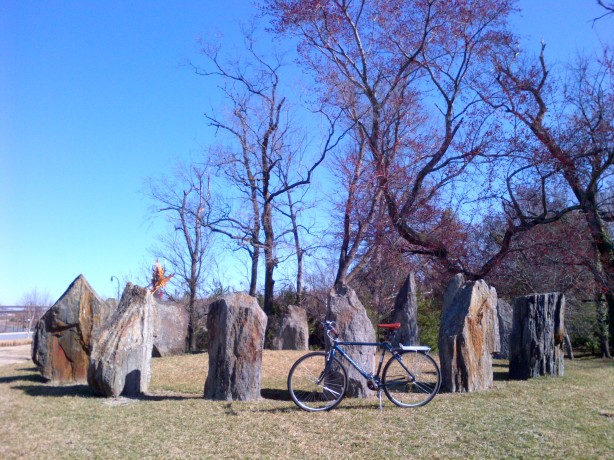
But I did ride to a miniature replica which was loosely based on the original monument. Located on a slight hill overlooking the entrance to National Harbor, near the intersection of Waterfront Street and National Harbor Boulevard in Fort Washington, Maryland (MAP), is a public art installation comprised of boulders arranged in a Stonehenge-like circular fashion. Very little information about the replica is available, giving it a slight air of mystery, much like its larger and more famous inspiration. But unlike the original, which receives nearly one million visitors per year, very few people, including those passing by it on their way to National Harbor, even know this stone monument exists.  But now you do.