Archive for the ‘Bridges’ Category

devilschair01

The Devil’s Chair Footbridge

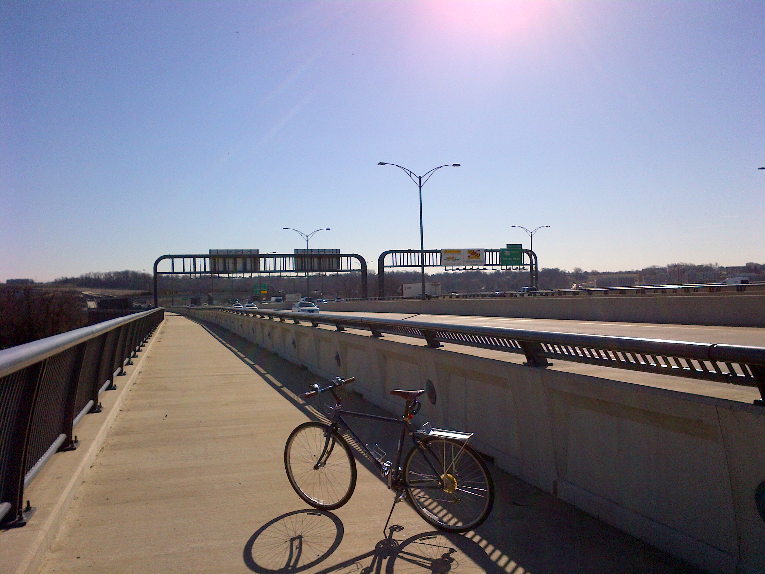
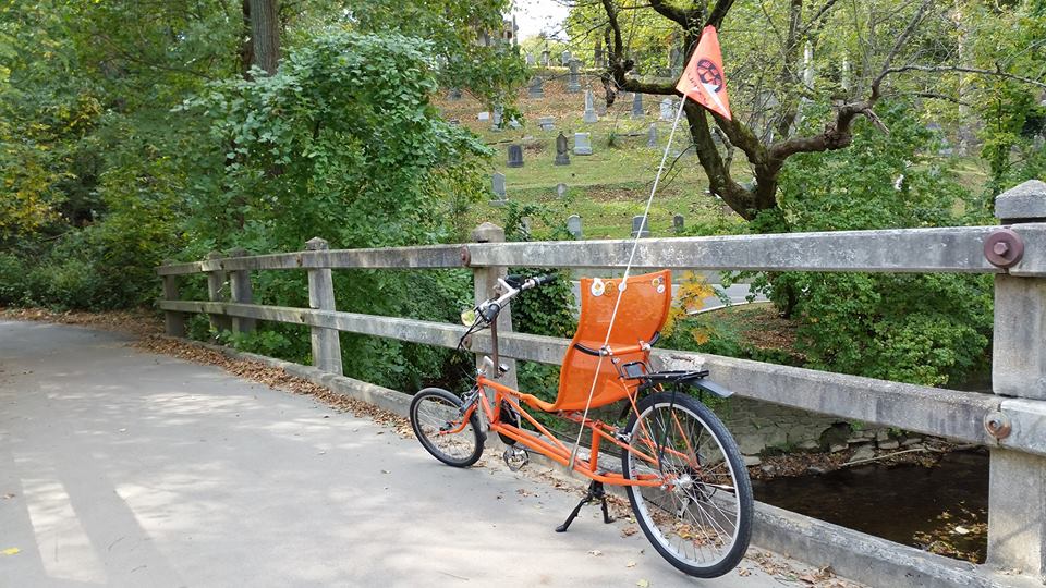
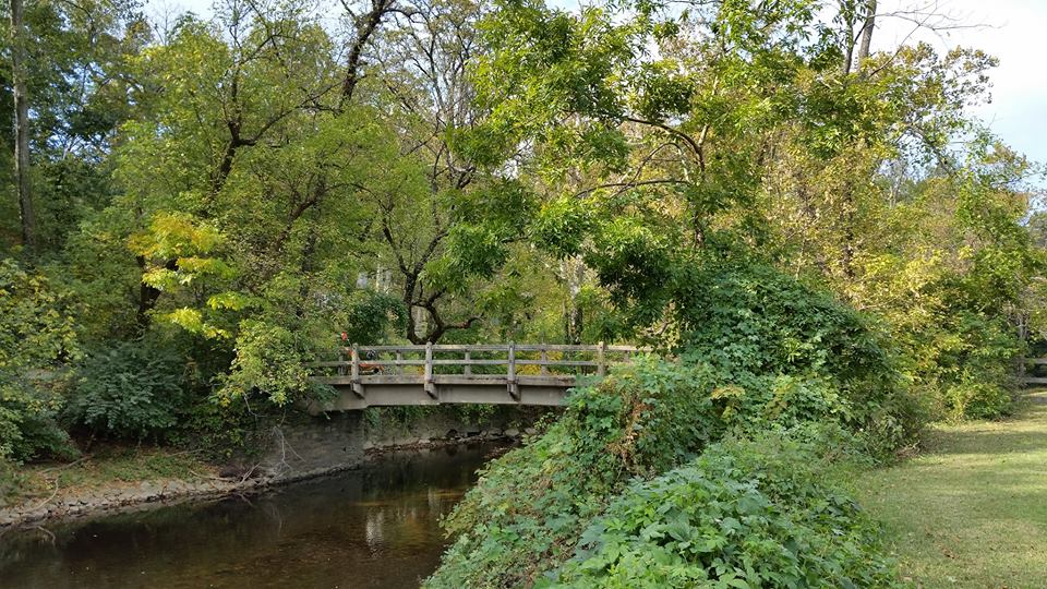
During this lunchtime bike ride, as I was riding on the Rock Creek Park Trail near the southern end of the park, I rode over Rock Creek on a bridge usually referred to as the Devil’s Chair Footbridge.  Located near Waterside Drive at a point approximately one-fifth of a mile northwest of where Q Street passes over the trail (MAP), with its eastern abutment just 30 feet from the southbound lanes of the Rock Creek and Potomac Parkway, the bridge’s name intrigued me.  So later after I got back from my ride I researched it to find out more.

Also called the Lyon’s Mill Footbridge, Devils Chair is the most notable of a series of eight footbridges built in Rock Creek Park as Public Works Administration projects during the Great Depression. It was completed in 1934, with the concrete, rustic-style bridge constructed in the style advocated by Albert H. Good, an architectural consultant to the National Park Service, in his sourcebook Park Structures and Facilities which was published the following year. The bridge lies in the shadow of Georgetown’s Oak Hill Cemetery on its western side, with its eastern abutment built on a remnant of the original Lyon’s Mill which had been located on the eastern bank of the creek.

The term devil’s chair usually refers to a memorial sculpture common in this country during the nineteenth century, when cemeteries sometimes included carved chairs for the comfort of visitors. In this function, the object was known as a mourning chair. Some carved chairs, however, were not intended for use as anything but monuments.  Anyway, once the original purpose of these chairs fell out of fashion, superstitions developed in association with the act of sitting in them. In a typical example, local young people dare one another to visit the cemetery, most often after dark, or on a certain night, such as Halloween. Variously, the stories suggest the person brave enough to sit in the chair at such a time may be punished for not showing due respect or rewarded for their courage.

So I assume the name Devil’s Chair is connected in some way to nearby Oak Hill Cemetery. But I have been unable to find one in the section of the cemetery near the footbridge. The rocky and hilly cemetery is both gothic and beautiful, but I have not found a devil’s chair anywhere in the cemetery. And despite researching it, I have been unable to find an explanation for the name. So the origins of the Devil’s Chair Footbridge’s name continues to be shrouded in mystery, at least for now.  So if anyone knows of the story behind the name, please contact me.  Otherwise, I may just have to go back there on Halloween next week, at midnight, and see if I can figure it out firsthand.

devilschair02     devilschair03     devilschair04

devilschair05     devilschair06     devilschair07
[Click on the photos to view the full-size versions]

WoodrowWilsonBridge01

The Woodrow Wilson Memorial Bridge

You would think that a mile and a quarter long, multi-span drawbridge which carries a twelve-lane interstate highway used by more than a quarter of a million vehicles every day would not be a very good location for riding a bicycle, but that is not the case with the Woodrow Wilson Memorial Bridge.

The Woodrow Wilson Memorial Bridge, commonly referred to as the Wilson Bridge, was planned and built as part of the Interstate Highway System created by Congress in 1956. Construction of the bridge began in the late 1950s, at which time it was called the Jones Point Bridge. It was renamed the “Woodrow Wilson Memorial Bridge” in honor of our country’s 28th President in 1956 by President Dwight D. Eisenhower as part of that year’s centennial celebration of Woodrow Wilson’s birth on December 28, 1856. President Wilson was an advocate of automobile and highway improvements in the United States, and during his presidency reportedly spent an average of two hours a day riding in his automobile to relax and, as he would say, “loosen his mind from the problems before him.”

The Wilson Bridge opened to traffic on December 28, 1961. First Lady Edith Wilson, the widow of President Wilson, was supposed to have been the guest of honor at the bridge’s dedication ceremony honoring her husband on what would have been his 105th birthday. However, she died that very morning at the family home they had shared in northwest D.C.

The Wilson Bridge as it was originally constructed was designed to handle between 70 and 75 thousand vehicles a day. But by 1999 the bridge was handling 200,000 vehicles a day. This caused not only traffic issues but serious maintenance problems as well. Despite undergoing continuous patchwork maintenance beginning in the 1970’s, and being completely re-decked in 1983, the overuse took its toll and in 2000 construction began to replace the bridge with two new side-by-side drawbridges. The massive $2.357 billion construction project utilized 26 prime contractors and 260 subcontractors employing 1,200 full-time workers.  The 230 thousand ton, 1.2-mile long structure was completed almost a decade later.

The Wilson Bridge currently consists of two parallel bridge structures, each with 17 fixed spans and one 270-foot twin double leaf bascule span. The northern span carries the Inner Loop of the Capital Beltway, which is comprised of Interstate 95 and Interstate 495, while the southern span contains the beltway’s Outer Loop.  And with eight leaves, each weighing four million pounds, giving the drawbridge 32 million pounds of moving mass, it is the biggest drawbridge in the world.

Connecting the city of Alexandria, Virginia, with National Harbor in Oxon Hill, Prince George’s County, Maryland, the Wilson Bridge also crosses the tip of the southernmost corner of D.C., giving it the distinction of being the only bridge in the United States that crosses the borders of three jurisdictions. The 300-foot mid-span of the western portion of the bridge is also the shortest segment of Interstate Highway between state lines.

But to me, one of the most impressive features of this massive structure was the forethought to make it bicycle friendly. The northern span of the bridge includes a pedestrian and bike passageway known as the Wilson Bridge Bike Trial. The 3.5-mile trail extends from Oxon Hill Road across the Potomac River to the Huntington Metro Station in Virginia. The trail connects to the network of trails, including the Mount Vernon Trail at Jones Point Park in Virginia.  And future plans call for it to connect with the Potomac Heritage Trail in Maryland. The trail has a steel railing on the north side called the bicycle barrier and a concrete barrier with a short steel railing on top called the combination barrier to separate the bikeway traffic from the highway traffic. The trail, which opened on June 6, 2009, is approximately 12 feet wide, with “bump-out” areas where users can stop to observe views of D.C. and Old Town Alexandria.

The Wilson Bridge Bike Trial has a speed limit of 10 m.p.h., which is a good idea due to the bridge’s many steel joints that can damage bike tires and rims at high speeds. The speed limit for bikes is also a good idea since the trail is also used by many pedestrians.  While riding on the trail it’s also a good idea to remember that it is a drawbridge and may open periodically, so paying attention to warning lights and bells is necessary. The trail is closed between midnight and 5:30 a.m.  It is also closed during snowstorms, so much like the D.C. area, it has had a rough go of it this winter.

WoodrowWilsonBridge01a     WoodrowWilsonBridge03     WoodrowWilsonBridge04
[Click on the thumbnails above to view the full size photos]

Jones Point Park

Jones Point Park

On this lunchtime bike ride I decided to go to Jones Point Park, which is located just south of Old Town Alexandria (MAP) in Virginia. The 65-acre park is operated by the National Park Service as land of the U.S. Department of Interior, and is located in an historic area on the banks of the Potomac River, on land which was a critical piece of the city of Alexandria’s early history as one of the largest centers for shipping, manufacturing, and transportation in the nation. A large portion of the park also is located under the massive The Woodrow Wilson Memorial Bridge, which crosses the Potomac River and connects Virginia with Maryland.

The park has formal spaces for recreation which include two playgrounds, one for children under age five and one for children ages six to ten. It has two basketball courts, restrooms, water fountains, picnic tables, multi-use recreational fields, as well as the historic Jones Point Lighthouse.

Jones Point Park also includes a small boat launch that offers access to the Potomac River for canoes and kayaks, and two fishing piers, which all provide excellent opportunities to cast for American catfish, rock bass, and American eels. Fishing is permitted with the appropriate license. However, the boundaries for Virginia, Maryland and the District of Columbia all intersect at Jones Point. So depending on where you fish, the regulations for the different entities will apply. Federal fishing regulations also apply throughout the park. For anyone wanting to fish in this area, they should be aware of the health advisories on eating fish caught in this area of the Potomac River. The advisories may be found on state and municipal fisheries websites.

Less formal areas of the park, including trails through an adjacent hardwood forest, are also available at the park by crossing the multi-use recreational fields. The 80-foot trees that make up the forest offer a haven for wildlife amid the local urban area, and are great habitat for viewing fall and spring birds that are drawn to these woodlands during migration in search of food and cover. And the trail down to the Potomac River offers spectacular views of waterbirds, wintering waterfowl and bald eagles. There is also an interpretive trail which provides information about the human and natural history behind Jones Point Park.  Signs and exhibits along the trail highlight the area’s fresh water marsh habitat, its use by American Indians, and its role in shipbuilding and navigation.

Jones Point Park is easily accessible by bike, because it is located along the Mount Vernon Trail, which actually runs through the park. So the next time you’re looking for a ride that’s a little bit longer, I highly recommend this park. It’s not only a great destination, but there’s plenty to see along the way during the ride from D.C.

JonesPointPark02     JonesPointPark04
[Click on the photos to view the full-size versions]

Arlington Memorial Bridge

Arlington Memorial Bridge

Widely regarded as D.C.’s most beautiful bridge, Arlington Memorial Bridge spans the Potomac River and is one of nine bridges that connect the National Capital City to the Commonwealth of Virginia. It is located at the western end of the National Mall (MAP), and in part constitutes a formal terminus of the Mall.

A masonry, steel, and stone arch bridge with a central drawbridge, Arlington Memorial Bridge was designed in the Neoclassical architectural style. Except for the draw span, the bridge is of reinforced concrete construction faced with dressed North Carolina granite ashlar. The draw span is of the double leaf, underneath counterweight type and is faced with pressed ornamental steel made to blend with the masonry spans. At the time it was built, the draw span was the longest, heaviest and fastest in the world, although it is now sealed and inoperative. The bridge is 2,163 feet long, carrying a 60-foot-wide roadway and 15-foot sidewalks on either side.

Arlington Memorial Bridge also contains some ornamental characteristics typical of the “City Beautiful Movement” which was taking place in D.C. at the time it was designed. This reform philosophy of North American architecture and urban planning flourished during the 1890s and 1900s with the intent of introducing beautification and monumental grandeur in cities. However, it promoted beauty not only for its own sake, but also to instill moral and civic virtue among urban populations. The northeastern entrance to the Arlington Memorial Bridge features “The Arts of War” sculptures, Sacrifice and Valor, which were completed by Leo Friedlander in 1951. On the pylons of each pier of the bridge are large circular discs with eagles and fasces designed by sculptor Carl Paul Jennewein.

Congress first proposed a bridge at the site of the current structure on May 24, 1886. However, the bridge went unbuilt for decades thanks to political quarrels over whether the bridge should be a memorial, and to whom or what. Then in November of 1921, President Warren G. Harding was travelling to the dedication ceremony for the Tomb of the Unknown Soldier at Arlington National Cemetery when he was caught in a three-hour traffic jam because the existing bridges at the time could not handle the traffic. Resolving to prevent that from happening again, President Harding sought an appropriation to fund the work to build a bridge. Congress subsequently approved his request in June of the following year. Construction finally began in 1927, and took six more years to complete. The dedication ceremony was on January 16, 1932, headed by President Herbert Hoover. Arlington Memorial Bridge was added to the National Register of Historic Places in 1980.

Today Arlington Memorial Bridge is a major entryway and commuter route into the city. But the years of heavy use have taken their toll, and although the bridge has received various relatively minor repairs over the years, it has never had a major overhaul or restoration. In a report two years ago, the Federal Highway Administration called for a complete overhaul of the bridge. And after a major inspection of the bridge, the National Park Service transportation division head Charles N. Borders, II, stated “The bridge … is really at the end of, and beyond, its life cycle.”

ArlingtonMemorialBridge03     ArlingtonMemorialBridge01a     MemorialBridge3

The Dumbarton Bridge

The Dumbarton Bridge

The Dumbarton Bridge, also sometimes referred to as the Buffalo Bridge or the Q Street Bridge, is an historic curved masonry arch bridge in northwest D.C., which conveys Q Street (MAP) across Rock Creek Park connecting the city’s DuPont Circle and Georgetown neighborhoods. The ornate neoclassical bridge with strong influences from Roman aqueducts was designed by Glenn Brown, with engineering design by Daniel B. Luten. It was added to the National Register of Historic Places in 1973.

What most likely would have been a plain and practical bridge had it been constructed during any other era, the Dumbarton Bridge was built in 1914-15 and influenced by what is known as the “City Beautiful Movement.” This reform philosophy of North American architecture and urban planning flourished during the 1890s and early 1900s, particularly in D.C., with the intent of introducing beautification and monumental grandeur in American cities. However, its goal was not just to promote beauty for its own sake, but also to instill moral and civic virtue among urban populations.

To accommodate the bridge’s approach and to keep the street continuous within Georgetown, the Dumbarton House, which at that time was known as Bellevue, was moved about 100 feet northward from its original site in the middle of the current Q Street to its present position on the north side of the street. However, the location of Dumbarton House was not the only construction problem facing the bridge. The proposed sections of Q Street, on either side of the bridge, were not aligned. This necessitated what turned out to be one of the bridge’s most unusual aesthetic features, its unusual curved design.

The bridge is most widely known because of its four buffalo sculptures, which are located on the sides of both ends of the bridge, and appear to be sentries standing guard. The buffalo were designed by American sculptor Phimister Proctor, who also designed the lion sculptures on the nearby Taft Bridge on Connecticut Avenue, and the tigers on the Piney Branch Parkway Bridge on 16th Street.

DumbartonBridge03     DumbartonBridge01

BoulderBridge01

Boulder Bridge in Rock Creek Park

Rock Creek Park is a large natural preserve with public park facilities that was established within a heavily urbanized area of northwest D.C.  It was established in 1890, and is the oldest and largest urban park in the national park system. Rock Creek Park is distinctive compared to other great American parks designed in the 19th century such as New York City’s Central Park, Golden Gate Park in San Francisco, or the Boston Metropolitan Park System.  It stands out because Rock Creek Park is not manmade.  It was created by the forces of nature.

Based on its natural origins, the National Park Service has tried to ensure that the any construction within the park has a natural and rustic appearance.  Built in 1902, Boulder Bridge is an excellent example of this approach.  In part due to its unique use of large boulders, the bridge does an outstanding job of standing out architecturally while at the same time blending in well with its natural surroundings.  Exemplifying the old phrase “pretty as a postcard,” the picturesque bridge has routinely appeared on post cards over the years.

Boulder Bridge is located on Beach Drive, approximately a mile and a half south of Joyce Road (MAP), and spans Rock Creek, a tributary of the Potomac River.  The arched bridge spans 80 feet and rises 12 feet, and was designed by architect W. J. Douglas.   Technically, the concrete-steel arch bridge utilizes the patented Melan method of construction with concrete reinforcement and a facing that utilizes rounded boulders similar to ones found naturally in the area.

Boulder Bridge is one of the oldest bridges in Rock Creek Park.  Many of the others from the park’s early years have been washed out in floods and replaced with newer ones.  This one, however, was clearly made to last.  Boulder Bridge was added to the National Register of Historic Places in 1980, and is a contributing property to the Rock Creek Park Historic District.

Interestingly, the use of such large boulders was not part of the original plan for the bridge.  The use of such sizable boulders happened due to a misunderstanding by the contractor.  Colonel Lansing H. Beach, of the Army Corps of Engineers, is credited with the original idea to use boulders in the construction of the bridge.  The plan called for the use of “man-sized” stones, a phrase which led to differing interpretations.   The plan itself envisioned man-sized as stones that could be handled by one man.  The contractor, however, gathered and began to construct the bridge using stones approximately the size of a man.   By the time Colonel Beach arrived at the construction site and saw the discrepancy, he liked the way it looked and the change became permanent.

BoulderBridgePostcard01