Posts Tagged ‘Prince Georges County’

BattleOfBladensburg01

Battle of Bladensburg Marines Memorial

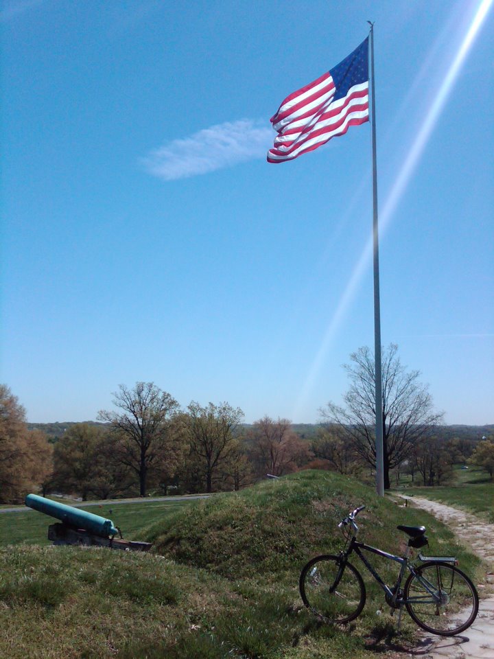
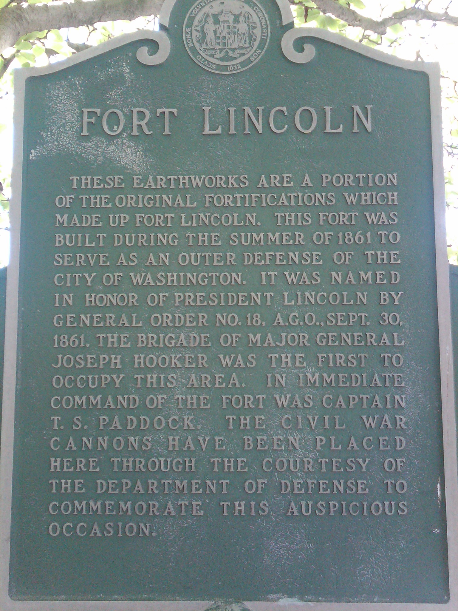
By the end of this long leisurely ride, or I should say the halfway point since I still needed to ride back to where I started, I found myself in Prince George’s County, Maryland.  As I rode around taking in the area, I came upon Fort Lincoln Cemetery, and realized I had been here before.  Located at 3401 Bladensburg Road in Colmar Manor, Maryland (MAP), I had previously discovered a number of historic sites on the cemetery grounds.  These sites include Historic Fort Lincoln and The Old Springhouse, as well as the nearby Bladensburg Dueling Grounds, located just outside of the cemetery.  With so many points of interest in the area, I decided to conduct some additional exploration and see what else I could find.  And I wasn’t disappointed.  

While riding around the expansive grounds within the cemetery, I saw what looked like a seating area behind the building with the mausoleum, which happens to be one of the grandest public mausoleums in the world.  It is very large, open to the public, and contains a beautiful garden.  So I decided to ride over to the seating are and take a break to relax.  But as I got there and upon closer inspection I found out that it was, in fact, a memorial rather than just a place to sit.  A stone marker at the entrance to the memorial reads, “This is the site of the Battle of Bladensburg. It was here that Commodore Barney and his marines were defeated in the War of 1812. The British moved on to burn the Capitol and White House.”  I quickly pulled up some information on my cellphone.  But naturally I was anxious to do more research and learn al about it later after I got home.  

I learned that the Battle of Bladensburg was part of what was known as the Chesapeake Campaign of the War of 1812.  As an aside, I have always the name odd inasmuch as the War of 1812 was fought over a nearly three-year period.  Anyway, caused by British restrictions on U.S. trade and America’s desire to expand its territory, the United States took on the greatest naval power in the world, Great Britain.  

Although neither side had gained a clear advantage in the first two years of the war, that changed in the spring of 1814 when Britain was able to disentangle itself from fighting France in the Napoleonic Wars.  After Napoleon Bonaparte’s exile in April 1814, British forces in the war with America could now be replenished with thousands of veterans. These soldiers were different than the soldiers Americans had faced in Upper Canada; these men had fought against Napoleon and his Imperial Guard and wanted a quick end to this war against a young country.  

The Battle of Bladensburg was fought on August 24, 1814, and America lost.  And in large part due to the fortification of British forces with combat-experienced veterans, it was a significant loss for America.  The defeat of General William Henry Winder and the 6,500 American men he had at his disposal allowed British Army Officer Robert Ross and his 4,500 men to subsequently march into nearby D.C.

President James Madison and his cabinet had already fled the city at that point, with Dolly Madison and White House slave Paul Jennings famously saving critical relics of their new republic, among them a portrait of George Washington.  And it was a good thing that they did because the British promptly set fire to the city’s public buildings, including the presidential mansion (later to be rebuilt and renamed as The White House) and the U.S. Capitol Building over the following couple of days.  The loss at the Battle of Bladensburg to a smaller but superior fighting force and the subsequent destruction of these symbols of American democracy devastated the morale of both American servicemen and the the public, and almost lead to the complete military defeat of the young American nation.    

Ultimately, the War of 1812 ended in a draw on the battlefield, and the peace treaty reflected this. The Treaty of Ghent was signed in modern-day Belgium on December 24, 1814, and went into effect on February 17, 1815, after both sides had ratified it.  And while Britain effectively won the War of 1812 by successfully defending its North American colonies, America also succeeded in not only maintaining it’s independence but expanding both U.S. trade and its territory as the country grew westward.  

So who was the Commodore Barney mentioned on the inscription at the memorial?  Joshua Barney was an American Navy officer who served in the Continental Navy during the Revolutionary War who later achieved the rank of commodore in the United States Navy.  During his service in the War of 1812 he commanded the Chesapeake Bay Flotilla, a fleet of gunboats tasked with defending Chesapeake Bay.  Concerned that Barney’s flotilla could fall into British hands, Secretary of the Navy John Paul Jones ordered Barney to take the flotilla as far up the Patuxent River as possible, to Queen Anne, and scuttle it if the British appeared.  Leaving his barges with a skeleton crew to handle any destruction of the craft, Barney took the majority of his men to join the American Army commanded by General  Winder where they participated in the Battle of Bladensburg.  

Subsequent to narrowly avoiding capture prior to the battle, President James Madison personally directed the Marines led by Barney, making the Battle of Bladensburg one of only two instances of a sitting president exercised direct battlefield authority as Commander-in-Chief.  The other was when George Washington personally crushed the Whiskey Rebellion.

Commodore Barney was severely wounded during the Battle of Bladensburg, receiving a bullet deep in his thigh that could never be removed.  He later on December 10, 1818, from complications related to the wound. His remains rest in Allegheny Cemetery in Pittsburgh.

I find it unusual that a memorial was built about what was a disastrous defeat for the United States.  But considering the dedication and bravery of men like Commodore Barney and the marines and other men who fought in that war, I think a memorial to them is fitting despite the loss at the Battle of Bladensburg.   

BattleOfBladensburg04     BattleOfBladensburg03
[Click on the photos to view the full-size versions]

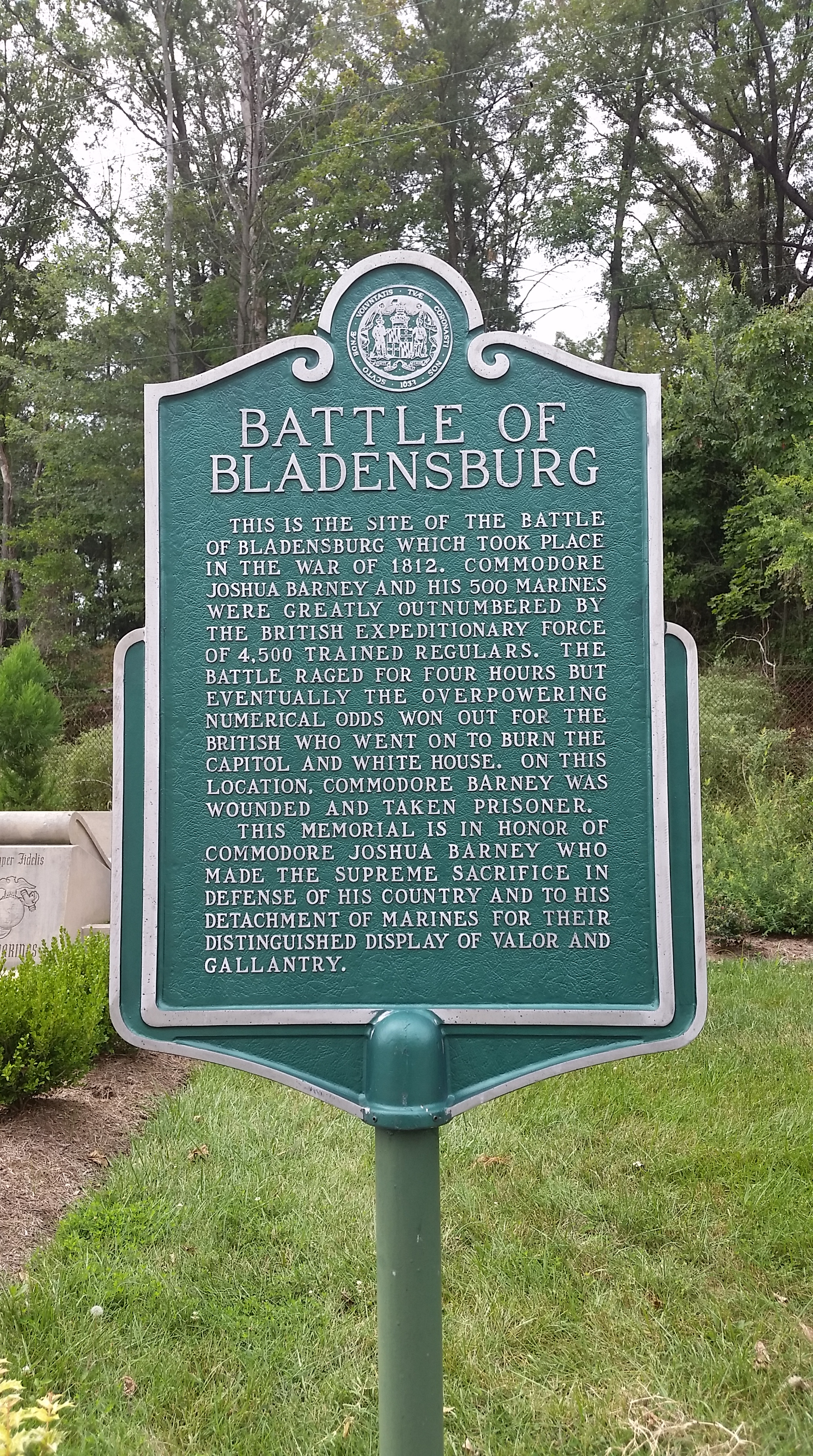
NOTE:  The historic marker (see photo above) reads:  “This is the site of the Battle of Bladensburg which took place in the War of 1812.  Joshua Barney and his 500 marines were greatly outnumbered by the British expeditionary force of 4,500 trained regulars. The battle raged for four hours but eventually the overpowering numerical odds won out for the British who went on to burn the Capitol and the White House. On this location, Commodore Barney was wounded and taken prisoner. This memorial is in honor of Commodore Joshua Barney who made the supreme sacrifice in defense of his country and to his detachment of marines for their distinguished display of valor and gallantry.”  

NOTE:  The Battle of Bladensburg Marines Memorial is different than the more famous Battle of Bladensburg Memorial, which is located at the battlefield, that has been preserved under the Prince George’s County Department of Parks and Recreation, and is located in Waterfront Park, down the street  between the Bladensburg Peace Cross and the George Washington House (two places I plan to ride to someday soon), at 4601 Annapolis Road in Bladensburg.  

Historic Fort Lincoln

Historic Fort Lincoln

After getting temporarily lost on a recent bike ride, I got out a map when I got back to my office to see where I had been.  It turned out that the area where I had been riding, which is just north of The National Arboretum, has as many, if not a greater number of historical sites than practically any other location I’ve seen of comparable size.  While looking at the map I also noticed that I had been very near historic Fort Lincoln, so on this ride I went back to explore.  There was too much too see in one trip, however, so I’ll have to plan to go back again.

Fort Lincoln was a Civil War-era fort constructed by the Union Army in 1861 for use in the defense of the national capital city.  The remnants of the fort are just past the D.C. city limits in Prince George’s County, Maryland, and is located at 3401 Bladensburg Road (MAP) in Brentwood, Maryland.  The fort is located within the boundaries of Fort Lincoln Cemetery, near the Old Spring House and adjacent to the infamous Bladensburg Dueling Grounds.

The area surrounding D.C. had 68 major enclosed forts, as well as 93 prepared, although unarmed, batteries for field guns, and seven blockhouses surrounding it during the Civil War.  This system of forts is known collectively as the Civil War Defenses of Washington, or the Fort Circle Parks.  Fort Lincoln was part of this system of forts.

Much of what remains of the system of forts is now a collection of National Park Service properties, while other forts have become state and city parks in the area.  Forts Foote, Greble, Stanton, Ricketts, Davis, Dupont, Chaplin, Mahan, and Battery Carroll are administered by National Capital Parks-East. Forts Bunker Hill, Totten, Slocum, Stevens, DeRussy, Reno, Bayard, Battery Kemble, and Battleground National Cemetery are administered by Rock Creek Park. And Fort Marcy is administered by George Washington Memorial Parkway.

There is also a trail connecting four of the parks, the Fort Circle Park National Recreation Trail, which is also operated and maintained by the National Park Service.

The inscription on the historic marker at the entrance to Fort Lincoln reads, “These earthworks are a portion of the original fortifications which made up Fort Lincoln. This fort was built during the summer of 1861 to serve as an outer defense of the city of Washington. It was named in honor of President Lincoln by General Order No. 18, A.G.O., Sept. 30, 1861. The brigade of Major General Joseph Hooker was the first to occupy this area. In immediate command of the fort was Captain T.S. Paddock. The Civil War cannons have been placed here through the courtesy of the Department of Defense to commemorate this auspicious occasion.”

I look forward to going back to the area near Fort Lincoln to explore more of the history there, as well as eventually visiting all of the other remaining Fort Circle Parks.

FortLincoln04     FortLincoln01a
[Click on the photos above to view the full size versions]

Mary Surratt's Gravesite

Mary Surratt’s Gravesite

Mary Surratt was a D.C. boarding house owner who was convicted of taking part in the conspiracy to assassinate President Abraham Lincoln. Sentenced to death, she was hanged on July 7, 1865, alongside three men who were also convicted of playing a part in the plot to assassinate the 16th President, thereby becoming the first woman executed by the United States federal government.

Mary Elizabeth Jenkins was born in Waterloo, Maryland, raised by her mother after her father died when she was still a toddler, and schooled in a Catholic female seminary. She married John Harrison Surratt at age seventeen, and they bought approximately 300 acres of land in Prince George’s County, Maryland, where they built a tavern and a post office.  There they raised three children, Isaac, Anna, and John Jr., on the property which became known at that time as Surrattsville.

After the Civil War began on April 12, 1861, Maryland remained part of “the Union,” but the Surratts were Confederate sympathizers. Isaac Surratt left Maryland and traveled to Texas, where he enlisted in the Confederate States Army, while John Jr. quit his studies at St. Charles College and became a courier for the Confederate Secret Service. And during the war, the tavern was thought to have doubled as a safe house for rebel agents and spies in the Confederate underground network.

When her husband suddenly collapsed and died in August of 1862, Mary found herself in dire financial straits and decided to move to D.C., where she lived in a townhouse her husband had previously purchased. The 39-year old widow rented out the family farm in Maryland, and converted the townhouse’s upper floor into a boardinghouse. Through renting the farm and operating the boarding house, Mary managed to eke out a modest living.

While debate among historians still continues over the role Mary and her boardinghouse played in Lincoln’s death, it is widely accepted that she hosted and possibly attended meetings about the conspiracy convened there by John Wilkes Booth and her son, John Jr.  Mary herself denied any involvement during her trial. After her conviction, attempts were made, particularly by her daughter, Anna, to persuade President Andrew Johnson to commute Mary’s death sentence. He refused, stating, “She kept the nest that hatched the egg.”

On this bike ride I chose to stop by some of the locations in D.C. that were part of both her life and her death. First I rode to the boarding house which she owned where John Wilkes Booth and his accomplices met. The building is still standing, and is located at 605 H Street (MAP) in northwest D.C.’s Chinatown neighborhood. Although the building has retained much of its original character, it is no longer a boarding house. The building is now a Chinese restaurant called Wok and Roll. An historic plaque next to the restaurant’s door reads, “A Historical Landmark, “Surratt Boarding House”, 604 H Street, N.W. (The 541), is said to have been where the conspirators plotted the abduction of U.S. President Abraham Lincoln in 1865, Plaque by Chi-Am Lions Club.”

I also rode to her final resting place, which is in Mount Olivet Cemetery, located at 1300 Bladensburg Road (MAP) in northeast D.C. This was the most interesting part of the bike ride. When I got to the cemetery I stopped at the front office to ask where Mary Surratt’s grave is located. Upon being told by the manager that they do not give out that kind of information, I assumed she did not recognize the name. So I explained that Mary Surratt was the Lincoln assassination conspirator who had been executed nearly 150 years ago. She said that Mary’s grave continued to be vandalized, even to this day, and that the family had specifically asked that information about the location of her grave not be given out.

However, because I was already there anyway, I decided to look around a little before I left.  I knew from researching it that she was buried in Section 31 of the cemetery.  A map at the entrance showed the different sections of the cemetery, but there was no Section 31 listed. So as I was riding around aimlessly looking at the very decorative gravestones of what must have been very wealthy and prominent people of that time period, it occurred to me that Mary Surratt would have been out of place among them. Having been a working class woman who was executed for her role in the assassination of the President, they would not have wanted her to be buried among them in that area of the cemetery. So I rode over to the other side of the cemetery – as far away as I could get from the most ornate gravestones in the cemetery. There I saw a small, very plain-looking gravestone that looked almost out of place for the cemetery. When I went up to it I saw that it read, simply, “Mrs. Surratt.”

MarySurratt04     MarySurratt05
[Click on the thumbnails above to view the full size photos]

Note:  Historic photos obtained from the Library of Congress Prints and Photographs Division.

National Harbor

National Harbor

On this bike ride I decided to go on a longer ride than usual, and made the 30-mile round trip out and back to National Harbor in Maryland. National Harbor is a 300-acre multi-use waterfront development on the shores of the Potomac River in Prince George’s County, Maryland, south of D.C. near the Woodrow Wilson Bridge. Its official address is 165 Waterfront Street in National Harbor, Maryland (MAP).

The land developed for National Harbor was previously the site of the Salubria Plantation. Originally built in 1827 by Dr. John H. Bayne, the site was renowned by local historians for its connection to Black history and to the Civil War. It was on the Salubria Plantation in 1834 that a 14-year-old slave girl named Juda, thought to have possibly been influenced by Nat Turner’s slave rebellion a few years earlier, poisoned her master’s two sons and infant daughter, and attempted to burn the house down, as an act of resistance to slavery. She is listed in the Maryland Archive as the first Maryland woman who was reported to have resisted slavery. She was tried and hanged in nearby Upper Marlborough, thus earning the dubious distinction of being the youngest female ever executed in the United States.

Despite the murders of his children, Dr. John Bayne became a Union officer in the Civil War, and went on to help convince the state of Maryland to compensate slave owners to free their slaves. He also later worked to provide public education to freedmen.

Despite being called “Hallowed African American Ground” in a headline by The Washington Business Journal, the site lost its historical designation and opportunity to be listed on the National Register of Historic Places when the plantation house burned down in 1981. Despite Prince Georges County being a majority Black county which ranks as the most educated and affluent Black county in the United States, a vote was taken by the Historic Preservation Commission to take away, not to nominate it for the national register. The remains of the plantation were then offered for sale along with the surrounding land. It sold in 1984, and was subsequently rezoned for mixed-use development.

Now known as National Harbor, the site has a convention center, six hotels, restaurants, condominiums, museums, stores, and an outlet mall. The site also has amusement rides, including a children’s carousel, and the Capital Wheel, a 175-foot ferris wheel on a pier that extends out into the Potomac River. National Harbor also includes a beachfront, where an outdoor sculpture entitled “The Awakening” currently resides, and a walking path. And an MGM-branded casino is expected to open at National Harbor within the next couple of years. It also hosts outdoor activities such as a culinary festival, famers markets, concerts by local artists, an annual ice sculpture exhibition, and an annual international Beatles festival.

However, access to National Harbor remains an issue. National Harbor has road access to Interstate 95/495 (the Beltway), Interstate 295 (Anacostia Freeway), and Oxon Hill Road. The state of Maryland has funded over a half a billion dollars in road improvements in order to handle the number of vehicles expected to drive daily to National Harbor. Since National Harbor is not accessible by the Metro, the Washington area’s rapid transit system, the state of Maryland also pays approximatley $312,000 annually for bus access to National Harbor from the Branch Avenue Metro station. A water taxi line run by the Potomac Riverboat Company also connects the National Harbor to Alexandria, Virginia. The City of Alexandria also runs shuttles from the water taxi terminal to the King Street/Old Town Metro station. The service costs the city almost a million dollars each year. Despite the government subsidies, National Harbor remains difficult to access via public transportation. I did, however, find it to be accessible by bike via the separated bike lane that crosses the Woodrow Wilson Bridge, but lacking in secure parking and storage facilities for your bike once you arrive.

     NationalHarbor05     NationalHarbor01      NationalHarbor04

NationalHarbor03     NationalHarbor06     NationalHarbor07


The Awakening

The Awakening

On this bike ride I went to see “The Awakening.”  The Awakening is a 70-foot sculpture depicting the arousing of a bearded giant who is embedded in the earth.  The sculpture was created by J. Seward Johnson, Jr., and owned by the Sculpture Foundation, a group that promotes public art.  It was part, along with 500 other pieces, of a city-wide public art exhibition in 1980.  After the exhibition it was subsequently loaned to the National Park Service for almost thirty years, who placed it on display at Hains Point in East Potomac Park in southwest D.C.   However, the sculpture was sold in 2008, and the new owner moved it to its current location at National Harbor in Prince Georges County, Maryland (MAP).

The Awakening consists of five separate cast aluminum pieces partially buried in the sand on the shores of the Potomac River.  Cumulatively they create the impression of a distressed giant emerging from the earth.  The left hand and right foot barely protrude, while the bent left leg and knee jut into the air.  The right arm and hand reach the farthest out of the ground.  The giant’s bearded face, with the mouth in mid-scream, appears to be concurrently angered and distressed as he struggles to free himself.

There is also a copy of the same statue just west of the Chesterfield Mall in West St Louis, Missouri, but that is a much longer bike ride from D.C.  So despite the move from Hains Point to National Harbor making the ride to see The Awakening a longer one than it used to be, it’s still the shorter of the two options, and was worth the effort.

TheAwakening01     TheAwakening03     TheAwakening04     Awakening01a